World Heritage Identification Number: 1545
World Heritage since: 2017
Category: Cultural Heritage
WHE Type: Cultural Landscapes
Transboundary Heritage: No
Endangered Heritage: No
Country: 🇿🇦 South Africa
Continent: Africa
UNESCO World Region: Africa
Map
ǂKhomani Cultural Landscape: A Testimony to Ancient Adaptation Strategies
The ǂKhomani Cultural Landscape, inscribed as a UNESCO World Heritage Site in 2017, is a significant testament to the resilience and adaptability of human cultures in some of the harshest environments on Earth. Located in the southern Kalahari, the site lies within and adjacent to the South African section of the Kgalagadi Transfrontier Park. It offers a unique glimpse into the rich history, land-use practices, and cultural traditions of the ǂKhomani San people.
Geographically, the ǂKhomani Cultural Landscape lies within the Northern Cape Province of South Africa, encompassing areas to the north of Upington. Located close to the borders of Botswana, and Namibia, this vast landscape serves as a living archive of human occupation dating back to the Stone Age, providing valuable insights into the strategies that enabled the ǂKhomani San to thrive in the Kalahari Desert.
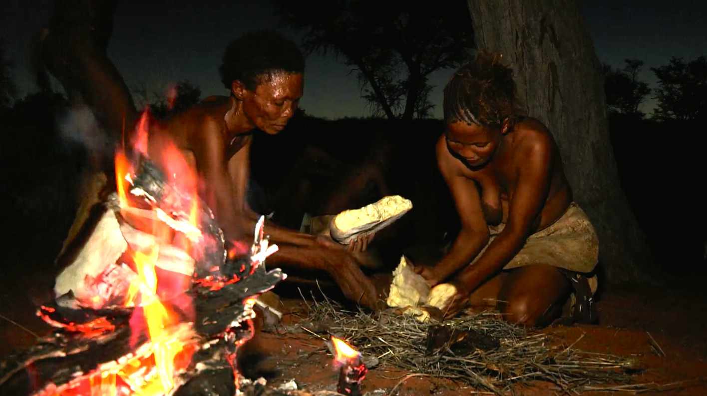
The ǂKhomani San people were traditionally nomadic hunter-gatherers who developed a deep understanding of their environment. Their ethnobotanical knowledge was essential for survival, allowing them to identify edible plants, medicinal herbs, and poisonous species. This intimate connection with the natural world extended beyond practical applications, shaping their spiritual beliefs, mythology, and social structures, embedding memory and meaning within the geography itself.
Unlike many other San-inhabited regions of southern Africa, the ǂKhomani Cultural Landscape contains few suitable rock formations for painting or engraving, and rock art is not a defining feature of the site. Nevertheless, the ǂKhomani represent a living cultural link to the wider artistic and intellectual traditions of San communities across southern Africa. Their cultural heritage can be connected to the extensive archival records of the |Xam San documented in the nineteenth century, as well as to the broader southern African corpus of San rock art.
This wider corpus of southern African San rock art provides invaluable insight into belief systems, ritual practices, and symbolic worlds closely related to those maintained in oral traditions. Such paintings and engravings serve as visual records of San history and belief systems, depicting scenes of daily life, hunting, and spiritual practices. Research into this body of art has provided important insights into San cosmology, symbolism, and social organization.
While rock art is a prominent feature of several other southern African World Heritage Sites, it is not the defining characteristic of the ǂKhomani Cultural Landscape. Instead, the site’s Outstanding Universal Value lies primarily in its testimony to a living cultural tradition and the enduring relationship between the ǂKhomani people and their environment.
Archaeological remains and cultural traces within the landscape provide important evidence of long-term human occupation and adaptation. The landscape itself is characterized by rolling red sand dunes, dry riverbeds such as the Nossob and Auob river systems, and seasonal water sources, each offering unique opportunities and challenges. These environmental features shaped patterns of movement and subsistence.
For example, the San would follow the migratory patterns of animals such as gemsbok and springbok, setting up temporary camps near reliable water sources during the dry seasons. Their mobility and ecological knowledge were crucial to survival in the Kalahari climate. The San used relatively simple yet highly effective technologies and survival strategies to exploit scarce resources such as water, or find plant foods in an extremely hostile environment.
During the 20th century, the ǂKhomani San experienced forced displacement and land dispossession, particularly following the establishment and expansion of protected conservation areas. In 1999, a landmark land restitution agreement restored significant portions of ancestral land to the ǂKhomani community, marking an important step toward cultural and economic revival. Today, descendants of the ǂKhomani continue to live in the broader region, working to preserve and revitalize traditional knowledge, language, and cultural practices while navigating the complexities of modern life.
Of enormous cultural significance is the survival within the ǂKhomani community of the last speakers of the critically endangered N|uu language, part of the !Ui branch of the Tuu language family. The preservation of this linguistic heritage represents the survival of one of the world’s most ancient documented language traditions.
The broader southern African region is widely recognized as one of the cradles of modern humankind, with archaeological evidence demonstrating the presence of anatomically modern humans more than 100,000 years ago. The hunting and gathering lifeways preserved within the ǂKhomani Cultural Landscape reflect one of the world’s longest enduring traditions of human adaptation to arid environments. In this sense, the landscape is uniquely expressive of a way of life closely associated with early modern human societies from which all people ultimately trace their deeper ancestry.
In summary, the ǂKhomani Cultural Landscape offers a fascinating window into the past, showcasing the remarkable adaptability and resilience of human cultures in one of the world's most inhospitable environments. By preserving this precious heritage, we not only honor the legacy of the ǂKhomani San but also gain valuable insights into one of humanity’s longest traditions of hunter-gatherer adaptation, rooted in a region central to the story of modern human origins. The 2017 UNESCO inscription recognizes both the deep historical roots and the contemporary cultural significance of the landscape.
UNESCO Description of the World Heritage Site
The ǂKhomani Cultural Landscape is located at the border with Botswana and Namibia in the northern part of the country, coinciding with the Kalahari Gemsbok National Park (KGNP). The large expanse of sand contains evidence of human occupation from the Stone Age to the present and is associated with the culture of the formerly nomadic ǂKhomani San people and the strategies that allowed them to adapt to harsh desert conditions. They developed a specific ethnobotanical knowledge, cultural practices and a worldview related to the geographical features of their environment. The ǂKhomani Cultural Landscape bears testimony to the way of life that prevailed in the region and shaped the site over thousands of years.
Encyclopedia Record: ǀXam and ǂKhomani heartland
The ǀXam and ǂKhomani heartland World Heritage Site consists of regions located to the South and North of Upington, respectively, in the Northern Cape Province of South Africa. The ǀXam and ǂKhomani people were linguistically related groups of San (Bushman) people, their respective languages being part of the ǃKwi language group. Descendants of both the ǀXam and Nǁnǂe include Afrikaans-speaking ‘Coloured’ people on farms or in towns in the region amongst whom the precolonial languages are either entirely extinct or can be spoken by but a very few people.Additional Site Details
Area: 959,100 hectares
(vi) — Directly associated with events or living traditions
Coordinates: -25.6876111111 , 20.3745833333
Image
© Francois Odendaal Productions (FOP Films). Used with permission.
