World Heritage Identification Number: 1161
World Heritage since: 2004
Category: Natural Heritage
WHE Type: Natural Landscapes & Geographic Features
Transboundary Heritage: No
Endangered Heritage: No
Country: 🇱🇨 Saint Lucia
Continent: Americas
UNESCO World Region: Latin America and the Caribbean
Map
The Pitons Management Area: A Unique Volcanic Landscape and Marine Ecosystem in Saint Lucia
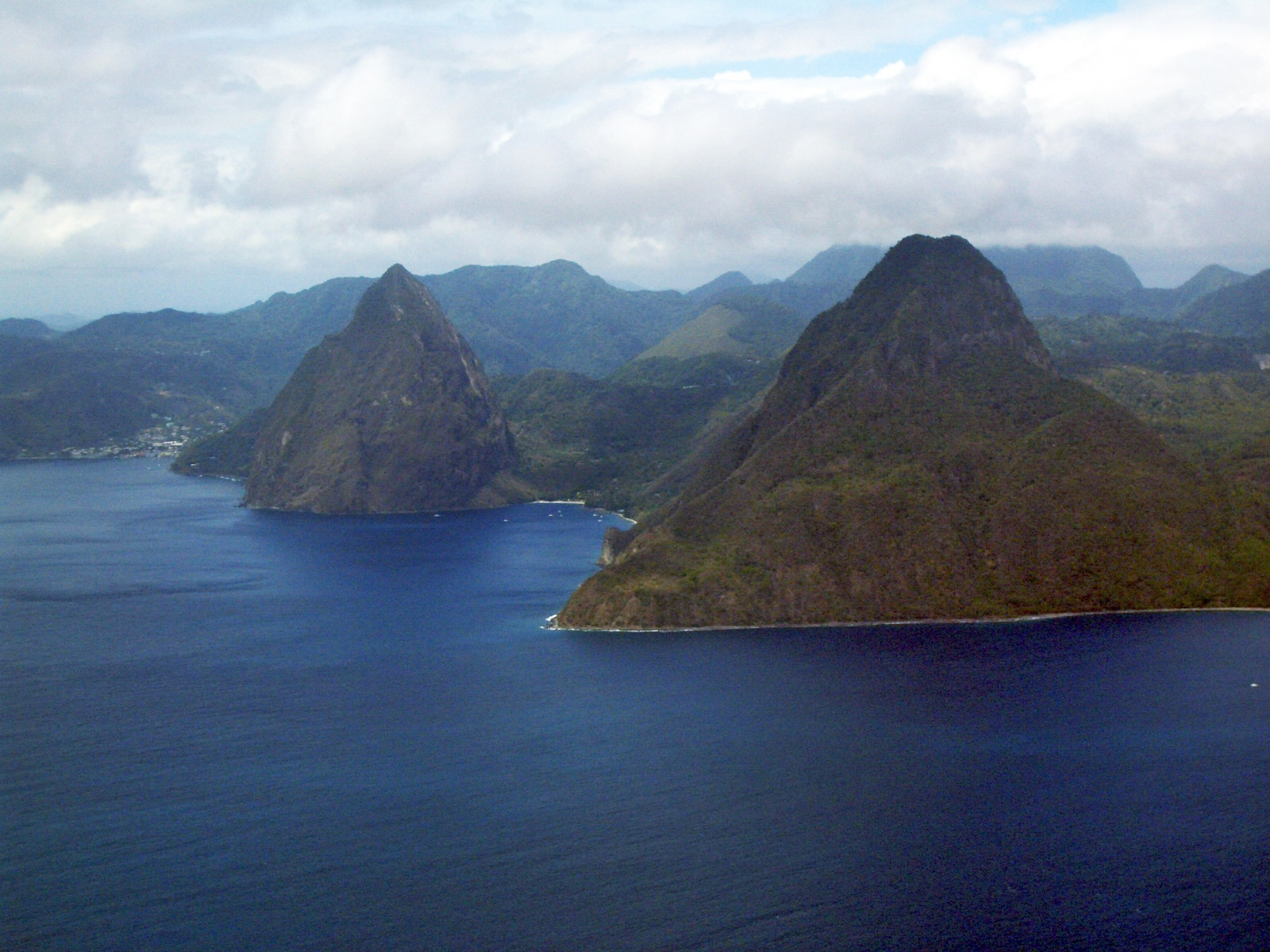
The Pitons Management Area, inscribed as a UNESCO World Heritage Site in 2004, offers a unique blend of volcanic landscapes, rich biodiversity, and vibrant marine ecosystems. Located near the town of Soufrière in the eastern Caribbean island nation of Saint Lucia, this 2,909-hectare protected area is home to the iconic twin peaks known as the Pitons – Petit Piton (743 meters high) and Gros Piton (798.25 meters).
More to come…UNESCO Description of the World Heritage Site
The 2,909-ha site near the town of Soufriere includes the Pitons, two volcanic spires rising side by side from the sea (770 m and 743 m high respectively), linked by the Piton Mitan ridge. The volcanic complex includes a geothermal field with sulphurous fumeroles and hot springs. Coral reefs cover almost 60% of the site’s marine area. A survey has revealed 168 species of finfish, 60 species of cnidaria, including corals, eight molluscs, 14 sponges, 11 echinoderms, 15 arthropods and eight annelid worms. The dominant terrestrial vegetation is tropical moist forest grading to subtropical wet forest, with small areas of dry forest and wet elfin woodland on the summits. At least 148 plant species have been recorded on Gros Piton, 97 on Petit Piton and the intervening ridge, among them eight rare tree species. The Gros Piton is home to some 27 bird species (five of them endemic), three indigenous rodents, one opossum, three bats, eight reptiles and three amphibians.
UNESCO Justification of the World Heritage Site
Criterion (vii): The PMA derives its primary visual impact and aesthetic qualities from the Pitons, two adjacent forest-clad volcanic spires rising abruptly from the sea to heights greater than 700 m.a.s.l. The Pitons predominate over the Saint Lucian landscape, being visible from virtually every part of the island and providing a distinctive landmark for seafarers. The combination of the Pitons against the backdrop of unspoilt lush and diverse natural tropical vegetation and a varying topography in a coastal setting gives the property its stunning natural beauty.
Criterion (viii): The PMA contains the greater part of a collapsed stratovolcano contained within the volcanic system, known to geologists as the Soufriere Volcanic Centre. Prominent within the volcanic landscape are two remnant volcanic peaks, Gros Piton and Petit Piton. The Pitons occur with a variety of other volcanic features including cumulo domes, explosion craters, pyroclastic deposits (pumice and ash), and lava flows. Collectively, these fully illustrate the volcanic history of an andesitic composite volcano associated with crustal plate subduction.
Encyclopedia Record: Pitons (Saint Lucia)
The Pitons are two mountainous volcanic plugs, volcanic spires, located in Saint Lucia. Petit Piton is 743 m (2,438 ft) high and Gros Piton is 798.25 m (2,618.9 ft) high; they are linked by the Piton Mitan ridge. Piton means mountain peak in French, so Petit and Gros Piton respectively refer to the smaller and larger peak. The Pitons are a World Heritage Site, 2,909 ha in size, and located near the town of Soufrière.Additional Site Details
Area: 2,909 hectares
Number of Components: 1
(viii) — Outstanding example representing major earth stages
Coordinates: 13.80708333 , -61.07036111
IUCN World Heritage Outlook
The 2025 Conservation Outlook on Pitons Management Area reports the following assessment:
Source: International Union for Conservation of Nature (IUCN) · View assessment
Image
© Unknown, CC BY-SA 3.0 Resized from original. (This derivative is under the same CC BY-SA license.)
World Heritage Research
Discover scientific research and academic studies that deepen our understanding of Pitons Management Area from its history and significance to its conservation, management, and contemporary challenges.
-
Distribution and cover of a recently introduced alien sedge species, Carex pilulifera L., in the subalpine vegetation of Reunion Island
A recent study identifies Carex pilulifera L., a European sedge, as an invasive species in Reunion Island's subalpine vegetation, with significant presence (16.6% cover) only on Piton de la Fournaise but potential for spread to Piton des Neiges. The species thrives near grazing and fodder areas, suggesting these as likely introduction pathways. Using generalized linear models (GLMs) and species distribution models (SDM), researchers found C. pilulifera to be the fourth most observed alien plant, predominantly in subalpine grasslands. The study highlights its invasive potential in high-biodiversity regions and recommends targeted management, including surveys in Piton des Neiges and control measures in Piton de la Fournaise to prevent further spread.
Boulesnane-Guengant, O., Soleyen, C., Fenouillas, P., Caubit, M., Dupont, J., L’Horset, R., & Rouget, M. (2024). Distribution and cover of a recently introduced alien sedge species, Carex pilulifera L., in the subalpine vegetation of Reunion Island. BioInvasions Records, 13(3), 589–605. https://doi.org/10.3391/bir.2024.13.3.03
View Publication Record | Read Publication -
Reappraisal of gap analysis for effusive crises at Piton de la Fournaise
A reappraisal of the gap analysis for effusive crises at Piton de la Fournaise reveals that the volcano's preparedness and response capabilities are far more robust than previously assessed. Contrary to earlier findings by Tsang and Lindsay (2020), this study demonstrates that Piton de la Fournaise has minimal gaps in knowledge due to extensive peer-reviewed literature and comprehensive observatory reports. The research corrects methodological flaws in prior analyses, emphasizing the critical role of the Observatoire Volcanologique du Piton de la Fournaise (OVPF-IPGP) in documenting 81 eruptions since 1979. It advocates for rigorous, third-party reviews to ensure gap analyses are thorough and accurate, leveraging all available scientific and observational resources.
Peltier, A., Chevrel, M. O., Harris, A. J. L., & Villeneuve, N. (2022). Reappraisal of gap analysis for effusive crises at Piton de la Fournaise. Journal of Applied Volcanology, 11(1). https://doi.org/10.1186/s13617-021-00111-w
View Publication Record | Read Publication -
Multitechnique Geochronology of Intrusive and Explosive Activity on Piton des Neiges Volcano, Réunion Island
A groundbreaking multitechnique geochronology approach has revolutionized our understanding of the geological history of Piton des Neiges, Réunion Island's main volcano. Researchers successfully dated major plutonic, metamorphic, and explosive events that were previously elusive, revealing four distinct stages of activity at 2,200–2,000 ka, 1,414 ± 8 ka, 665 ± 78 ka, and 150–110 ka. Notably, the study pinpointed a major Plinian eruption to 188.2 ± 10.4 ka, coinciding with caldera formation, and revised the last eruption date to 27 ka from an earlier estimate of 12 ka. This innovative method, combining zircon U-Pb, phlogopite 40Ar/39Ar, and (U-Th)/He dating techniques, demonstrates the efficacy of diversified approaches in accurately assessing volcanic activity timing, with significant implications for hazard prediction.
Famin, V., Paquez, C., Danišík, M., Gardiner, N. J., Michon, L., Kirkland, C. L., Berthod, C., Friedrichs, B., Schmitt, A. K., & Monié, P. (2022). Multitechnique Geochronology of Intrusive and Explosive Activity on Piton des Neiges Volcano, Réunion Island. Geochemistry, Geophysics, Geosystems, 23(5). Portico. https://doi.org/10.1029/2021gc010214
View Publication Record | Read Publication -
Structured elicitation of expert judgement in real-time eruption scenarios
A structured expert elicitation exercise conducted remotely for Piton de la Fournaise volcano, La Réunion, revealed that an uncommon effusive eruption scenario—with a vent outside the caldera and within inhabited areas—would likely present distinct characteristics compared to recent eruptions. Involving 28 experts from nine countries, this study demonstrated the feasibility of tele-elicitation for volcanic crisis management, providing critical uncertainty ranges for hazard-related questions such as eruption probability and lava flow timing. The findings underscore the importance of integrating well-prepared expert elicitations into civil protection evacuation plans to enhance disaster response procedures.
Tadini, A., Harris, A., Morin, J., Bevilacqua, A., Peltier, A., Aspinall, W., Ciolli, S., Bachèlery, P., Bernard, B., Biren, J., Brum da Silveira, A., Cayol, V., Chevrel, O., Coppola, D., Dietterich, H., Donovan, A., Dorado, O., Drenne, S., Dupéré, O., et al. (2022). Structured elicitation of expert judgement in real-time eruption scenarios. Volcanica, 5(1), 105–131. https://doi.org/10.30909/vol.05.01.105131
View Publication Record | Read Publication -
22 years of satellite imagery reveal a major destabilization structure at Piton de la Fournaise
A major destabilization structure at Piton de la Fournaise, capable of triggering catastrophic volcanic collapses, has been identified through 22 years of satellite imagery analysis. This spoon-shaped structure, characterized by a continuum of displacement from no slip to sheared sills and pure slip, connects arcuate dyke intrusions at depth with sill intrusions transitioning into a fault zone toward the sea. The study highlights how repeated magmatic intrusions into this structure could lead to significant flank failures, posing risks of large earthquakes and tsunamis. Researchers used inverse modeling to map 57 intrusive events between 1998 and 2020, shedding light on the complex interplay between dyke and sill intrusions and their role in volcanic instability.
Dumont, Q., Cayol, V., Froger, J.-L., & Peltier, A. (2022). 22 years of satellite imagery reveal a major destabilization structure at Piton de la Fournaise. Nature Communications, 13(1). https://doi.org/10.1038/s41467-022-30109-w
View Publication Record | Read Publication -
Volcanic crisis management supported by near real-time lava flow hazard assessment at Piton de la Fournaise, La Réunion
A near real-time lava flow hazard assessment protocol, implemented at Piton de la Fournaise (La Réunion) since 2018, significantly enhances volcanic crisis management by providing rapid, discharge-rate-dependent hazard maps. These maps, shared with civil protection within hours of an eruption, improve mitigation strategies through iterative collaboration between scientists and authorities. The study demonstrates how this integrated satellite data-driven approach tailors hazard assessments to local needs, addressing gaps in real-time decision-making during effusive crises.
Chevrel, M. O., Harris, A., Peltier, A., Villeneuve, N., Coppola, D., Gouhier, M., & Drenne, S. (2022). Volcanic crisis management supported by near real-time lava flow hazard assessment at Piton de la Fournaise, La Réunion. Volcanica, 5(2), 313–334. https://doi.org/10.30909/vol.05.02.313334
View Publication Record | Read Publication -
Lava flow hazard map of Piton de la Fournaise volcano
Piton de la Fournaise, one of the world's most active basaltic shield volcanoes on La Réunion island, poses significant lava flow hazards, particularly outside its uninhabited Enclos caldera. A new study presents an up-to-date lava flow hazard map for the volcano, highlighting that while the majority of eruptions (95%) occur within the Enclos—visited by over 100,000 people annually—the probability of future lava flows remains low (< 0.1%) in inhabited areas outside this region. The map, based on vent distribution, recurrence times, lava flow statistics, and simulations using the DOWNFLOW model, indicates up to 12% inundation probability within the Enclos but only 0.5% along active rift zones outside it. However, the study acknowledges potential underestimation due to limited historical records and suggests that atypical large-volume eruptions could pose greater risks than currently modeled. Regular updates of digital elevation models (DEMs) are recommended to maintain accurate hazard assessments for land use planning and risk mitigation.
Chevrel, M. O., Favalli, M., Villeneuve, N., Harris, A. J. L., Fornaciai, A., Richter, N., Derrien, A., Boissier, P., Di Muro, A., & Peltier, A. (2021). Lava flow hazard map of Piton de la Fournaise volcano. Natural Hazards and Earth System Sciences, 21(8), 2355–2377. https://doi.org/10.5194/nhess-21-2355-2021
View Publication Record | Read Publication