World Heritage Identification Number: 1317
World Heritage since: 2010
Category: Natural Heritage
WHE Type: Protected Areas & National Parks
Transboundary Heritage: No
Endangered Heritage: No
Country: 🇫🇷 France
Continent: Europe
UNESCO World Region: Europe and North America
Map
Exploring the Natural Wonders of the Pitons, Cirques, and Remplarts of Reunion Island
The Pitons, Cirques, and Remplarts of Reunion Island, inscribed as a UNESCO World Heritage Site in 2010, offers a breathtaking display of nature's grandeur and diversity. Situated in the southwestern Indian Ocean, this French overseas department boasts a unique landscape that captivates visitors with its rugged terrain, towering volcanic peaks, and diverse ecosystems.
More to come…UNESCO Description of the World Heritage Site
The Pitons, cirques and remparts of Reunion Island site coincides with the core zone of La Réunion National Park. The property covers more than 100,000 ha or 40 % of La Réunion, an island comprising two adjoining volcanic massifs located in the south-west of the Indian Ocean. Dominated by two towering volcanic peaks, massive walls and three cliff-rimmed cirques, the property includes a great variety of rugged terrain and impressive escarpments, forested gorges and basins creating a visually striking landscape. It is the natural habitat for a wide diversity of plants, presenting a high level of endemism. There are subtropical rainforests, cloud forests and heaths creating a remarkable and visually appealing mosaic of ecosystems and landscape features.
UNESCO Justification of the World Heritage Site
Criterion (vii): The combination of volcanism, tectonic landslide events, heavy rainfall and stream erosion have formed a rugged and dramatic landscape of striking beauty, dominated by two towering volcanoes, the dormant Piton de Neiges and the highly active Piton de la Fournaise. Other major landscape features include Remparts - steep rock walls of varying geological age and character, and so-called cirques, which can be described as massive natural amphitheatres with an imposing height and verticality. There are deep, partly forested gorges and escarpments, with subtropical rainforests, cloud forests and heaths creating a remarkable and visually appealing mosaic of ecosystems and landscape features.
Criterion (x): The property is a global centre of plant diversity with a high degree of endemism. It contains the most significant remaining natural habitats for the conservation of the terrestrial biodiversity of the Mascarene Islands, including a range of rare forest types. Given the major and partly irreversible human impacts on the environment in the Mascarene archipelago, the property serves as the last refuge for the survival of a large number of endemic, threatened and endangered species.
Encyclopedia Record: Réunion National Park
Réunion National Park is a National Park of France located on the island of Réunion, an overseas department in the western Indian Ocean. Established on 5 March 2007, the park protects the endemic ecosystems of Les Hauts, Réunion's mountainous interior, and covers around 42% of the island. Notable endemic species include the Réunion cuckooshrike and the Reunion Island day gecko.Additional Site Details
Area: 105,838 hectares
Number of Components: 1
(x) — Contains most important habitats for biodiversity
Coordinates: -21.0994444444 , 55.48
IUCN World Heritage Outlook
The 2025 Conservation Outlook on Pitons, cirques and remparts of Reunion Island reports the following assessment:
Source: International Union for Conservation of Nature (IUCN) · View assessment
Image
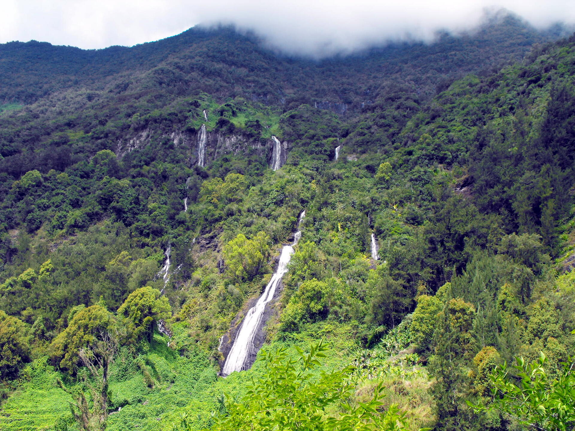
© Geolina, CC BY-SA 4.0 Resized from original. (This derivative is under the same CC BY-SA license.)
World Heritage Research
Discover scientific research and academic studies that deepen our understanding of Pitons, cirques and remparts of Reunion Island from its history and significance to its conservation, management, and contemporary challenges.
-
Evidences of Plug Pressurization Enhancing Magma Fragmentation During the September 2016 Basaltic Eruption at Piton de la Fournaise (La Réunion Island, France)
During the September 2016 eruption of Piton de la Fournaise volcano on Réunion Island, a sudden shift from typical effusive activity to explosive ash and bomb emission occurred. This transition was linked to the pressurization of a degassed, cooled magma plug beneath a secondary vent (Vent B), which enhanced magma fragmentation. The study integrated geophysical data with textural and petrological analyses, revealing that the explosive phase involved denser, crystal-rich tephra (sideromelane and tachylite) alongside more gas-permeable, vesicular fragments (golden pumice and fluidal scoria). Permeability measurements and chemical analyses suggested that the sideromelane and tachylite components originated from subsurface crystallization of the initial magma types. This finding highlights the potential danger posed by such transitions in volcanic activity, particularly for tourist areas accustomed to 'gentle' eruptions.
Thivet, S., Gurioli, L., Di Muro, A., Derrien, A., Ferrazzini, V., Gouhier, M., Coppola, D., Galle, B., & Arellano, S. (2020). Evidences of Plug Pressurization Enhancing Magma Fragmentation During the September 2016 Basaltic Eruption at Piton de la Fournaise (La Réunion Island, France). Geochemistry, Geophysics, Geosystems, 21(2). Portico. https://doi.org/10.1029/2019gc008611
View Publication Record | Read Publication -
The 2007 caldera collapse of Piton de la Fournaise volcano: Source process from very-long-period seismic signals
In April 2007, Piton de la Fournaise volcano on Réunion Island experienced its largest caldera collapse in at least 300 years, characterized by a series of 48 subsidence increments with seismic signals equivalent to magnitudes Mw 4.4 to 5.4. Analysis of these very-long-period (VLP) seismic events revealed a piston-like mechanism driven by the contraction of the magma reservoir and the collapse of the overlying rock column. The study found that the collapse dynamics were primarily controlled by rapid magma withdrawal, likely from a bubbly state, leading to an acceleration in subsidence increments—a pattern similar to the 2018 Kīlauea collapse. This suggests that such events are linked to progressive weakening of the volcanic edifice and increasing rates of magma extraction.
Duputel, Z., & Rivera, L. (2019). The 2007 caldera collapse of Piton de la Fournaise volcano: Source process from very-long-period seismic signals. Earth and Planetary Science Letters, 527, 115786. https://doi.org/10.1016/j.epsl.2019.115786
View Publication Record | Read Publication -
Control of source fertility on the eruptive activity of Piton de la Fournaise volcano, La Réunion
Research on Piton de la Fournaise volcano, Réunion Island, reveals that its eruptive activity is directly linked to the fertility of its mantle source. The study demonstrates that decadal-scale eruptive sequences are initiated by melt extraction from fertile, incompatible element-enriched veins within the plume source, while reactive flow of enriched melts increases mantle porosity, promoting further melt extraction. This dual control mechanism led to a fourfold increase in magma supply between 1998 and 2014, offering insights into similar surges at other hotspot volcanoes like Kilauea, Hawaii. The findings highlight the critical role of lithological heterogeneities in mantle plumes in regulating short-term eruptive activity.
Vlastélic, I., Di Muro, A., Bachèlery, P., Gurioli, L., Auclair, D., & Gannoun, A. (2018). Control of source fertility on the eruptive activity of Piton de la Fournaise volcano, La Réunion. Scientific Reports, 8(1). https://doi.org/10.1038/s41598-018-32809-0
View Publication Record | Read Publication -
Uncovering the hidden signature of a magmatic recharge at Piton de la Fournaise volcano using small earthquakes
A ring-shaped zone of weakness beneath Piton de la Fournaise volcano, revealed through advanced seismic analysis, suggests preexisting structural vulnerabilities that influence eruptive behavior. Using a template matching method, researchers detected thousands of small earthquakes in 2014 and 2015, uncovering persistent seismicity patterns linked to magma recharge. Notably, deep earthquake migration in 2015 preceded a shallow seismic swarm, indicating the formation of a hydraulic connection between deep magma sources and a near-sea-level reservoir—likely missed in past observations due to detection limitations. This study highlights how subtle seismic signals can decode volcanic processes, offering insights into the hidden dynamics shaping eruptions at UNESCO-listed Réunion Island's volcanic landscapes.
Lengliné, O., Duputel, Z., & Ferrazzini, V. (2016). Uncovering the hidden signature of a magmatic recharge at Piton de la Fournaise volcano using small earthquakes. Geophysical Research Letters, 43(9), 4255–4262. Portico. https://doi.org/10.1002/2016gl068383
View Publication Record | Read Publication -
Improved detection of preeruptive seismic velocity drops at the Piton de La Fournaise volcano
Researchers have identified a previously undetected preeruptive seismic velocity drop of 0.15% associated with the June 21, 2014 eruption at Piton de La Fournaise volcano on Réunion Island. This discovery was made possible by correcting seismic velocity data for pore pressure changes caused by rainfall, which had previously obscured the signal. The study used a transfer function to model the relationship between fluid pressure and seismic velocity variations, allowing for the isolation of true preeruptive signals during a period of low eruptive activity (2011–2013). This advancement improves the potential for more reliable volcanic eruption prediction by mitigating interference from environmental factors.
Rivet, D., Brenguier, F., & Cappa, F. (2015). Improved detection of preeruptive seismic velocity drops at the Piton de La Fournaise volcano. Geophysical Research Letters, 42(15), 6332–6339. Portico. https://doi.org/10.1002/2015gl064835
View Publication Record | Read Publication -
Long‐term mass transfer at Piton de la Fournaise volcano evidenced by strain distribution derived from GNSS network
Piton de la Fournaise, a basaltic volcano on Reunion Island, exhibits long-term mass transfer from its summit to the eastern flank, contributing to the formation of the Grandes Pentes relief. This process is evidenced by strain distribution analysis derived from a dense GNSS network installed since 2007. The study reveals that during summit deflation (2011-2014), the upper eastern flank extended eastward while the lower flank contracted, steepening the topographic slope. This deformation regime indicates progressive loading of the lower flank by the upper one, suggesting a potential instability. The research also highlights how volcanic 'pulsation'—alternating inflation and deflation—enhances rock fracturing, reduces stiffness, and increases permeability, providing insights into the volcano's structural dynamics.
Peltier, A., Got, J.-L., Villeneuve, N., Boissier, P., Staudacher, T., Ferrazzini, V., & Walpersdorf, A. (2015). Long‐term mass transfer at Piton de la Fournaise volcano evidenced by strain distribution derived from GNSS network. Journal of Geophysical Research: Solid Earth, 120(3), 1874–1889. Portico. https://doi.org/10.1002/2014jb011738
View Publication Record | Read Publication -
Timing of a large volcanic flank movement at Piton de la Fournaise Volcano using noise-based seismic monitoring and ground deformation measurements
A significant volcanic flank movement at Piton de la Fournaise (PdF) Volcano, La Réunion Island, was detected using noise-based seismic monitoring and ground deformation measurements. The study revealed that a large velocity reduction in seismic signals began just days before the major 2007 April 2 eruption, coinciding with widespread flank movement triggered by magma injection. This finding underscores the potential of combining seismic velocity changes with geodetic observations to monitor hazardous slope instabilities, providing critical insights for volcanic hazard assessment.
Clarke, D., Brenguier, F., Froger, J.-L., Shapiro, N. M., Peltier, A., & Staudacher, T. (2013). Timing of a large volcanic flank movement at Piton de la Fournaise Volcano using noise-based seismic monitoring and ground deformation measurements. Geophysical Journal International, 195(2), 1132–1140. https://doi.org/10.1093/gji/ggt276
View Publication Record | Read Publication