
World Heritage Identification Number: 773
World Heritage since: 1997
Category: Mixed Cultural Heritage and Natural Heritage
WHE Type: Protected Areas & National Parks
Transboundary Heritage: Yes
Endangered Heritage: No
Country: France, Spain
Continent: Europe
UNESCO World Region: Europe and North America
Map
Exploring the Pyrénées - Mont Perdu: A Transboundary World Heritage Site
The Pyrénées - Mont Perdu, inscribed as a World Heritage Site in 1997, is a testament to the breathtaking beauty and rich geological history of the Pyrenees mountain range. Spanning the contemporary national borders of France and Spain, this outstanding mountain landscape offers a unique blend of natural wonders and cultural heritage.
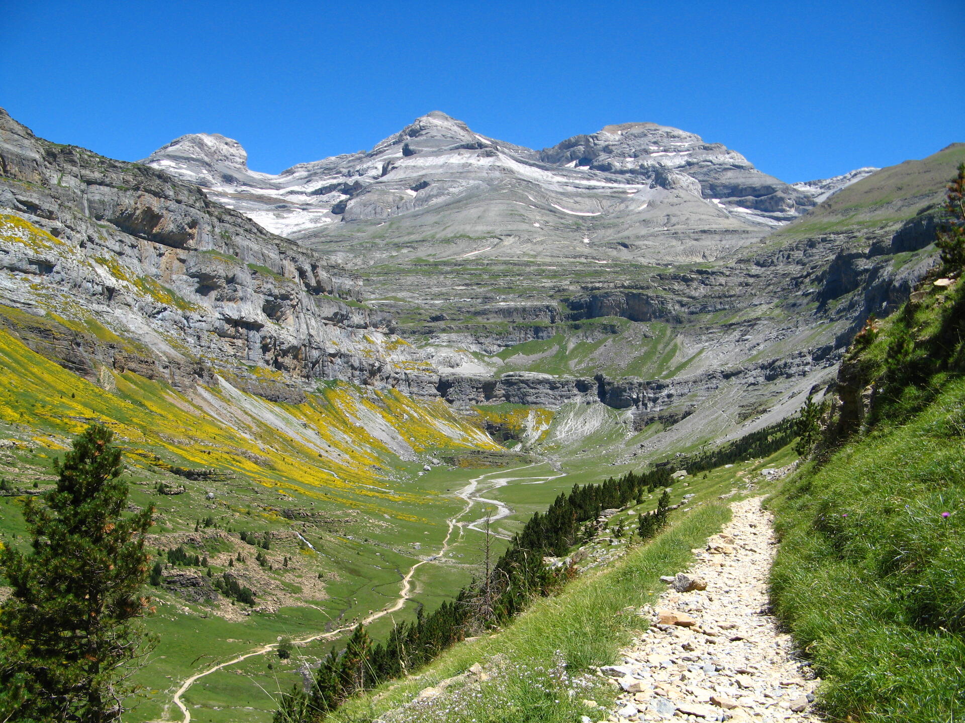
Central to the site is the peak of Mont Perdu, a calcareous massif that soars to a height of 3,355 meters (11,007 feet). The site covers a total area of 30,639 hectares, encompassing two of Europe's largest and deepest canyons on the Spanish side and three major cirque walls on the more rugged northern slopes that face France. These geological landforms provide a fascinating insight into the formation and evolution of the Pyrenees.
The geological significance of the Pyrénées - Mont Perdu extends beyond its dramatic scenery. The landscape was shaped by the collision of the Iberian and Eurasian tectonic plates, which uplifted the Pyrenees millions of years ago. Subsequent glacial erosion, together with the gradual dissolution of its extensive limestone formations, created a spectacular karst landscape of towering cliffs, deep canyons, cirques, caves, and underground drainage systems. Together, these features offer exceptional insights into the geological evolution of one of Europe's most impressive mountain ranges.
One of the most striking features of the Pyrénées - Mont Perdu is its spectacular glacial and karst terrain. On the Spanish side, the Valle de Ordesa and the Valle de Añisclo form two of Europe's largest and deepest canyons, with towering cliffs, narrow gorges, and lush vegetation. Together, these dramatic landforms create some of the most impressive scenery in the Pyrenees.
The French side is distinguished by three magnificent glacial cirques—Gavarnie, Troumouse, and Estaubé. Carved by ancient glaciers, these vast amphitheater-like formations are enclosed by towering limestone cliffs and rank among the finest examples of glacial landforms in Europe. The Cirque de Gavarnie is particularly renowned for the Grande Cascade de Gavarnie, one of Europe's highest waterfalls. Together with the deep canyons on the Spanish side, these features create one of the continent's most dramatic mountain landscapes.
Beyond its geological significance, the Pyrénées - Mont Perdu preserves a living cultural landscape that reflects centuries of pastoral traditions in the Pyrenees. The region is dotted with traditional villages, farms, cultivated fields, upland pastures, and mountain roads, offering a glimpse into an agricultural way of life that was once widespread throughout Europe's upland regions but has since declined significantly. The site provides valuable insights into how people have adapted to and interacted with this rugged yet beautiful environment over time.
In addition to its geological and cultural attractions, the wide range of elevations, from forested valleys to alpine meadows and rocky summits, supports a rich diversity of flora and fauna, including the Pyrenean chamois, the bearded vulture, and the Pyrenean desman. Its rich biodiversity reflects the complex interplay between geology, climate, and centuries of traditional land use in shaping the region's ecosystems.
The World Heritage Site was extended in 1999 to include the Commune of Gèdre in France. This boundary modification underscores the transboundary nature of the site and the shared commitment of both France and Spain to preserving and promoting this extraordinary World Heritage Site.
Today, the Pyrénées – Mont Perdu stands as a remarkable example of a transboundary World Heritage Site, showcasing a harmonious blend of natural beauty, geological history, cultural heritage, and biodiversity. Its designation recognizes its Outstanding Universal Value while underscoring the importance of continued conservation and sustainable management of this exceptional mountain landscape.
UNESCO Description of the World Heritage Site
This outstanding mountain landscape, which spans the contemporary national borders of France and Spain, is centred around the peak of Mount Perdu, a calcareous massif that rises to 3,352 m. The site, with a total area of 30,639 ha, includes two of Europe's largest and deepest canyons on the Spanish side and three major cirque walls on the more abrupt northern slopes with France, classic presentations of these geological landforms. The site is also a pastoral landscape reflecting an agricultural way of life that was once widespread in the upland regions of Europe but now survives only in this part of the Pyrénées. Thus it provides exceptional insights into past European society through its landscape of villages, farms, fields, upland pastures and mountain roads.
UNESCO Justification of the World Heritage Site
Criterion (iii): The pastures and meadows of the Pyrénées – Mont Perdu, with their villages and trails that link them, are a remarkable witness of a very rare transhumance system in Europe, still practised by seven communities that mainly live adjacent to the property.
Criterion (iv): The high valleys and the calcareous summits of the Pyrénées – Mont Perdu are an outstanding example of a landscape shaped by a pastoral transhumance system that was developed in the Middle Ages and still exists today.
Criterion (v): The model of the habitat of the Pyrénées – Mont Perdu with its villages, fields and meadows, as the basis of a seasonal migration of men and animals to the high pastures during the summer season, is an outstanding example of a type of transhumance that was once widespread in the mountainous regions of Europe, but which today is rare.
Criterion (vii): The property is an exceptional landscape with meadows, lakes, caves, mountains and forests. In addition, the region is of great interest for science and conservation, possessing a panoply of geological, panoramic, faunistic and floristic elements that make it one of the most important Alpine protected areas in Europe.
Criterion (viii): The calcareous massif of Mont Perdu presents a series of classic geological landforms such as the deeply-incised canyons and spectacular cirques. The region is distinguished by its location at the tectonic collision point between the Iberian and west European plates. The property presents an exceptional geological unity, forming a calcareous massif withMont Perdu at its centre. The resulting landscape is considerably different on the northern slopes (France) and the southern slopes (Spain).
Encyclopedia Record: Pyrénées – Mont Perdu World Heritage Site
The Pyrénées – Mont Perdu World Heritage Site is a World Heritage Site straddling the border between Spain and France in the Pyrenees mountain chain. The summit of Monte Perdido is on the Spanish side of the border. The site was designated in 1997 and extended north in 1999 to include the Commune of Gèdre in France.Additional Site Details
Area: 30,639 hectares
Number of Components: 1
(iv) — Outstanding example of a type of building or landscape
(v) — Outstanding example of traditional human settlement
(vii) — Contains superlative natural phenomena or beauty
(viii) — Outstanding example representing major earth stages
Coordinates: 42.68542 , -5e-04
IUCN World Heritage Outlook
The 2025 Conservation Outlook on Pyrénées - Mont Perdu reports the following assessment:
Source: International Union for Conservation of Nature (IUCN) · View assessment
Image
© Patrick Rouzet, CC BY-SA 3.0 Resized from original. (This derivative is under the same CC BY-SA license.)