World Heritage Identification Number: 1708
World Heritage since: 2024
Category: Cultural Heritage
WHE Type: Archaeological Sites
Transboundary Heritage: No
Endangered Heritage: No
Country: 🇮🇹 Italy
Continent: Europe
UNESCO World Region: Europe and North America
Map
The Appian Way: A Journey Through Time - Regina Viarum
The Appian Way, officially known as the Via Appia, holds a significant place in history as one of the earliest and most important of the great roads constructed by the Ancient Romans. Inscribed on the UNESCO World Heritage List in 2024 as Via Appia. Regina Viarum, this remarkable network extends for more than 800 kilometers across Italy, connecting Rome to the strategic port of Brindisi in the southeast.
Originally conceived as a strategic military road, the Via Appia played a crucial role in Rome’s expansion into southern Italy during the Samnite Wars and later facilitated connections to the eastern Mediterranean. Its importance is reflected in its celebrated title regina viarum, or “queen of the roads,” a designation recorded by the poet Statius.
The construction of the Via Appia commenced in 312 BCE under the leadership of Appius Claudius Caecus, a Roman censor during the Samnite Wars. The initial stretch connected Rome to Capua, establishing a durable model of Roman road engineering that would endure for centuries.
Over time, the Via Appia facilitated not only military movement but also trade, communication, and urban development. Settlements, villas, and agricultural estates flourished along its course, strengthening economic exchange between regions and integrating newly conquered territories into the Roman state.
While the primary route covered approximately 540 to 580 kilometers, over the centuries, the Via Appia evolved beyond its original route. Under Emperor Trajan in the 2nd century CE, the road was extended southward to Brindisi along what is now known as the Via Appia Traiana, strengthening Rome’s connections with the eastern Mediterranean. This extension made the Appian Way a vital artery for trade, travel, and communication, linking the heart of the Roman Empire with distant regions and underscoring its lasting strategic and cultural importance.
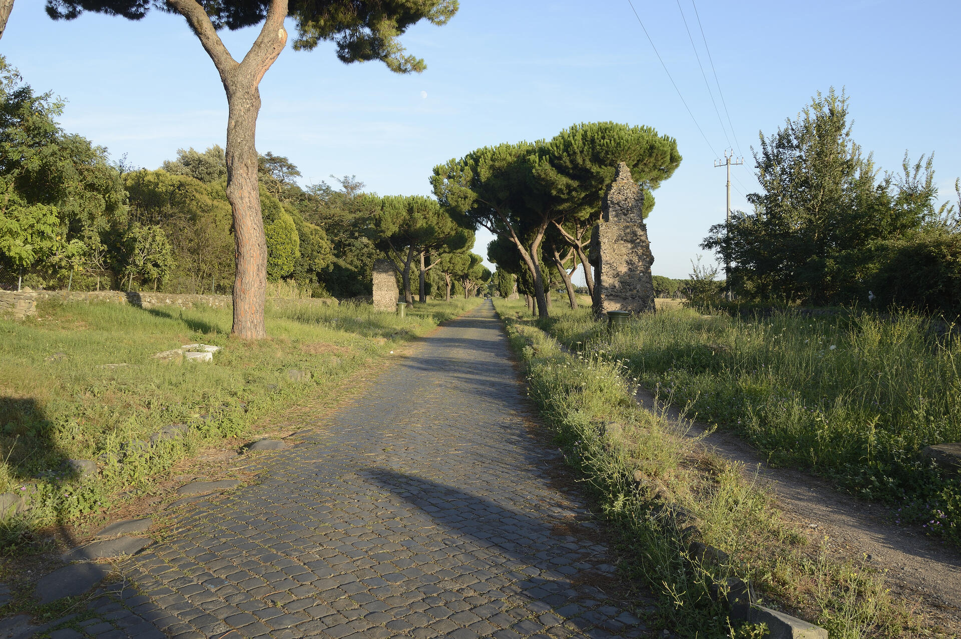
One of the most striking aspects of the Via Appia is the series of monumental funerary complexes and engineering works that line its route. These include tombs, catacombs, bridges, milestones, and impressive sections of original basalt paving. Such structures testify to the advanced technical skill of Roman engineers and to the cultural practice of commemorating the dead along major roads leading out of Rome.
Walking along the Via Appia, visitors can also encounter the monumental tombs and catacombs that were later used by early Christian communities. Pilgrims once traveled here to honor saints and martyrs, giving the road a spiritual significance that complements its historical and architectural value.
The road also crossed challenging terrain, including the Pontine Marshes, where drainage and land management projects were undertaken to improve passage and agricultural potential. These ambitious projects transformed barren landscapes into fertile farmland, demonstrating the Romans’ capacity to reshape landscapes in support of infrastructure and economic development.
In addition to its historical and architectural significance, the Via Appia offers a unique insight into the culture, society, and daily life of the Roman Empire. Walking along surviving stretches of the ancient pavement, one can imagine the movement of soldiers, merchants, pilgrims, and officials who once traversed this vital artery of the Roman world.
Today, the Via Appia remains a compelling destination for visitors and scholars alike. Comprising 22 component parts, this UNESCO World Heritage Site includes landmarks such as the Arch of Drusus, the Tomb of Cecilia Metella, and the Catacombs of Saint Callixtus, offering a powerful journey through more than two millennia of history. Protected within areas such as the Appia Antica Regional Park, these roads, monuments, and landscapes allow visitors to experience the rich layers of Roman life and heritage firsthand.
Overall, the Appian Way stands as a symbol of the ingenuity, ambition, and cultural achievements of the Ancient Roman civilization. It is more than just a road—it is a living record of centuries of history, where the layers of military strategy, civic planning, trade, funerary customs, and early Christian devotion intersect. As a UNESCO World Heritage Site, the Via Appia allows visitors to walk in the footsteps of soldiers, merchants, pilgrims, and ordinary Romans, experiencing firsthand the scale and ambition of the empire that built it.
UNESCO Description of the World Heritage Site
More than 800 kilometres long, the Via Appia is the oldest and most important of the great roads built by the Ancient Romans. Constructed and developed from 312 BCE to the 4th century CE, it was originally conceived as a strategic road for military conquest, advancing towards the East and Asia Minor. The Via Appia later enabled the cities it connected to grow and new settlements emerged, facilitating agricultural production and trade. This property, composed of 19 component parts, is a fully developed ensemble of engineering works, illustrating the advanced technical skill of Roman engineers in the construction of roads, civil engineering projects, infrastructure and sweeping land reclamation works, as well as a vast series of monumental structures including, for example, triumphal arches, baths, amphitheatres and basilicas, aqueducts, canals, bridges, and public fountains.
Encyclopedia Record: Appian Way
The Appian Way is one of the earliest and strategically most important Roman roads of the ancient republic. It connected Rome to Brindisi, in southeast Italy. Its importance is indicated by its common name, recorded by Statius, of Appia longarum... regina viarum. The road is named after Appius Claudius Caecus, the Roman censor who, during the Samnite Wars, began and completed the first section as a military road to the south in 312 BC.Additional Site Details
Area: 4,639.92 hectares
(iv) — Outstanding example of a type of building or landscape
(vi) — Directly associated with events or living traditions
Coordinates: 41.2927222222 , 13.2627222222
Image
© Livioandronico2013, CC BY-SA 4.0 Resized from original. (This derivative is under the same CC BY-SA license.)
