World Heritage Identification Number: 39
World Heritage since: 1979
Category: Mixed Cultural Heritage and Natural Heritage
WHE Type: Protected Areas & National Parks
Transboundary Heritage: No
Endangered Heritage: No
Country: 🇹🇿 United Republic of Tanzania
Continent: Africa
UNESCO World Region: Africa
Map
Ngorongoro Conservation Area: A Unique Blend of Wildlife, Culture, and History
The Ngorongoro Conservation Area, located in the Crater Highlands region of northeastern Tanzania, is a remarkable testament to the harmonious coexistence of diverse ecosystems, abundant wildlife, rich cultural heritage, and significant historical artifacts. Inscribed as a UNESCO World Heritage Site in 1979 and later recognized for its cultural significance in 2010, this expansive protected area offers a unique blend of natural beauty, wildlife spectacles, and human history that captivates visitors from around the globe.
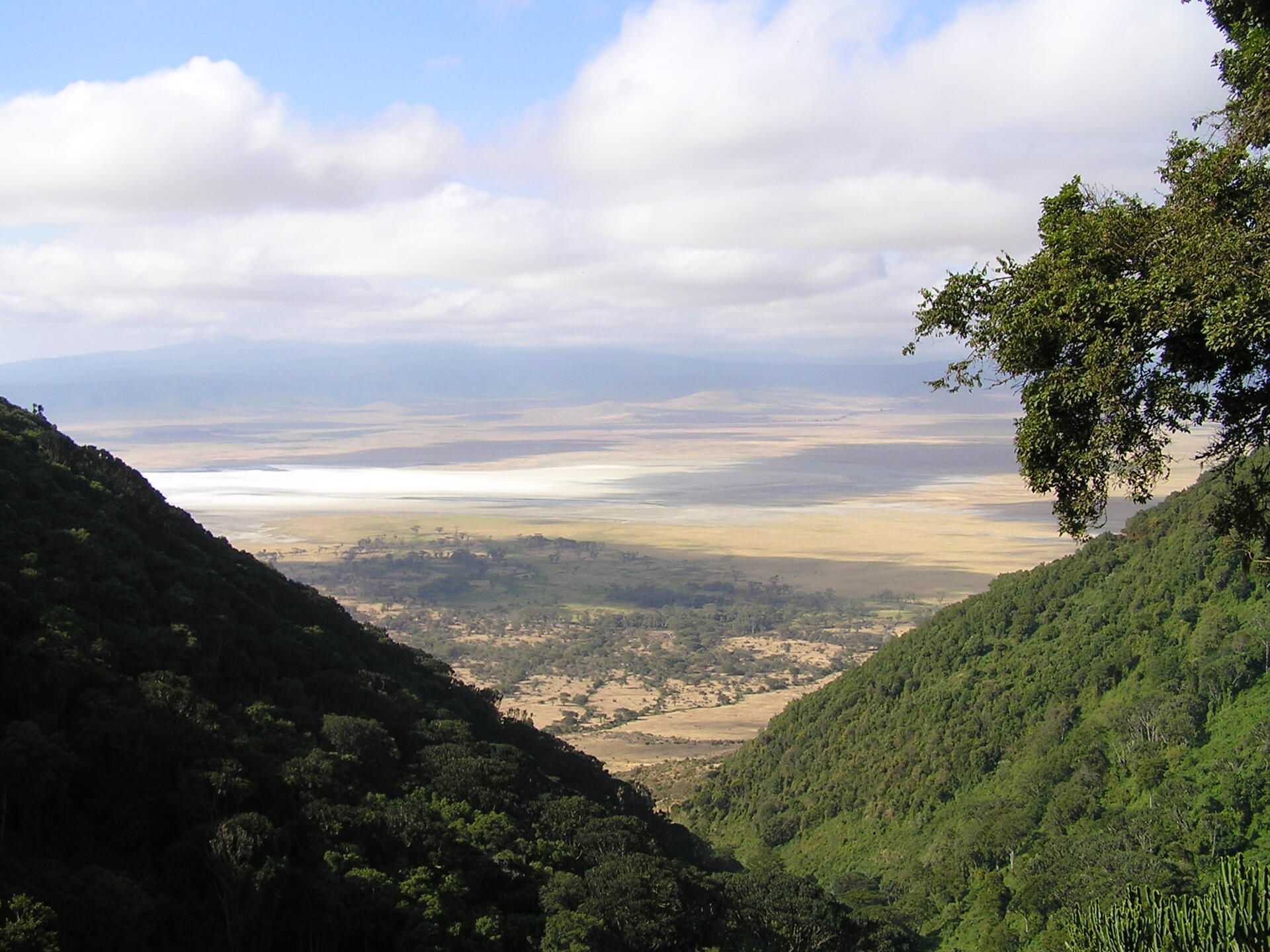
Covering an area of approximately 8,292 square kilometers, the Ngorongoro Conservation Area encompasses a wide range of landscapes, from highland plains and savannas to savanna woodlands and forests. Its most iconic feature is the Ngorongoro Crater, one of the world’s largest intact and unfilled volcanic calderas, measuring about 20 kilometers in diameter and over 600 meters deep. This breathtaking geological formation provides a sanctuary for a staggering array of wildlife, making it a must-visit destination for nature enthusiasts.
The dramatic landscape of the Ngorongoro Crater owes its origin to a massive volcanic eruption and subsequent collapse approximately 2 to 3 million years ago. Once a towering volcano comparable in scale to Mount Kilimanjaro, the structure imploded to form the caldera seen today. Over time, natural processes created a self-contained ecosystem within the crater, complete with grasslands, freshwater springs, and a soda lake, all of which support its remarkable concentration of wildlife.
The crater's diverse habitats support a dense population of wildlife, including the Big Five – lion, elephant, buffalo, rhino, and leopard – as well as numerous other species such as hyenas, cheetahs, zebras, wildebeests, and gazelles. Unlike the famous Great Migration of the Serengeti National Park ecosystem, much of the wildlife within the crater is largely resident year-round, contributing to consistently excellent game viewing. The Ngorongoro Conservation Area is also renowned for its birdlife, boasting over 500 recorded bird species, ranging from eagles and vultures to storks and flamingos.
Ecologically, the conservation area forms an integral part of the greater Serengeti ecosystem. While the crater itself sustains largely resident animal populations, the surrounding plains serve as vital corridors for seasonal wildlife movements. The area also acts as a critical refuge for threatened species, including the endangered Black rhinoceros, and supports one of the highest densities of large predators in Africa, further underscoring its global conservation significance.
The property's significance extends beyond its natural riches, as it also holds a wealth of archaeological and anthropological treasures. Olduvai Gorge, located within the conservation area, is one of the most important paleoanthropological sites in the world. Nearby, at Laetoli, early hominid footprints dating back approximately 3.6 million years have provided invaluable insights into human evolution and early human-environment interactions.
A defining, yet complex, feature of the Ngorongoro Conservation Area is its relationship with the Maasai people, who have lived in harmony with the land for centuries. The area was established in 1959 as a multiple land-use area, allowing the Maasai to continue their traditional livestock grazing practices alongside wildlife conservation efforts. However, this relationship has become increasingly strained.
Managed by the Ngorongoro Conservation Area Authority (NCAA), the region faces mounting pressures from population growth, increased tourism, and environmental change. In addition, human rights organizations and international observers have raised concerns over policies affecting Maasai communities, including restrictions on land use and access to essential services. Rights groups have criticized these measures as forms of displacement linked to conservation and tourism priorities, while government authorities maintain that such actions are necessary to protect the ecological integrity of the area.
In recent years, the "multiple land-use" model has faced its most severe test to date, drawing significant international criticism. As of 2026, United Nations human rights experts and human rights organizations like Survival International have intensified calls for the Tanzanian government to halt the forced relocation of over 80,000 Maasai residents. Critics allege that the government has used conservation as a pretext to clear the land for luxury tourism, reportedly restricting access to vital health services, schools, and grazing lands to pressure the community into leaving.
The Maasai International Solidarity Alliance (MISA) has issued a call for the Ngorongoro Conservation Area to be delisted as a UNESCO World Heritage Site. Indigenous leaders argue that the UNESCO designation has been weaponized by the state to justify displacement, prioritizing international conservation status over the human rights of the land’s original custodians. UN Special Rapporteurs have urged the government to honor its 1959 commitments, asserting that the protection of biodiversity must not come at the cost of the Maasai’s cultural and physical survival.
Overall, the Ngorongoro Conservation Area remains one of the most extraordinary landscapes on Earth—distinguished not only by its natural beauty and ecological richness but also by its deep historical roots and living cultural traditions. Its World Heritage status reflects its global importance, while its evolving management highlights the ongoing challenge of balancing conservation with human rights, dignity, and resilience in a changing world.
UNESCO Description of the World Heritage Site
The Ngorongoro Conservation Area spans vast expanses of highland plains, savanna, savanna woodlands and forests. Established in 1959 as a multiple land use area, with wildlife coexisting with semi-nomadic Maasai pastoralists practicing traditional livestock grazing, it includes the spectacular Ngorongoro Crater, the world’s largest caldera. The property has global importance for biodiversity conservation due to the presence of globally threatened species, the density of wildlife inhabiting the area, and the annual migration of wildebeest, zebra, gazelles and other animals into the northern plains. Extensive archaeological research has also yielded a long sequence of evidence of human evolution and human-environment dynamics, including early hominid footprints dating back 3.6 million years.
Encyclopedia Record: Ngorongoro Conservation Area
Ngorongoro Conservation Area is a protected area and a UNESCO World Heritage Site located in Ngorongoro District, 180 km (110 mi) west of Arusha City in Arusha Region, within the Crater Highlands geological area of northeastern Tanzania. The area is named after Ngorongoro Crater, a large volcanic caldera within the area. The Ngorongoro Conservation Area Authority (NCAA), which administers the Ngorongoro Conservation Area (NCA), is an arm of the Tanzanian government and its boundaries follow the boundary of the Ngorongoro District in the Arusha Region. The western portion of the park abuts the Serengeti National Park (SNP). The area comprising the NCA, SNP, and Kenya's Maasai Mara game reserve is home to Great Migration, a massive annual migration of millions of wildebeest, zebras, gazelles, and other animals. The NCA also contains Olduvai Gorge, one of the most important paleoanthropological sites in the world.Additional Site Details
Area: 809,440 hectares
(vii) — Contains superlative natural phenomena or beauty
(viii) — Outstanding example representing major earth stages
(ix) — Outstanding example representing ecological and biological processes
(x) — Contains most important habitats for biodiversity
Coordinates: -3.18722 , 35.54083
Image
© Jantjeerkamp at Dutch Wikipedia, CC BY-SA 3.0 Resized from original. (This derivative is under the same CC BY-SA license.)
