World Heritage Identification Number: 516
World Heritage since: 1989
Category: Mixed Cultural Heritage and Natural Heritage
WHE Type: Cultural Landscapes
Transboundary Heritage: No
Endangered Heritage: No
Country: 🇲🇱 Mali
Continent: Africa
UNESCO World Region: Africa
Map
Bandiagara Escarpment: A Cultural and Geological Marvel in the Heart of Mali
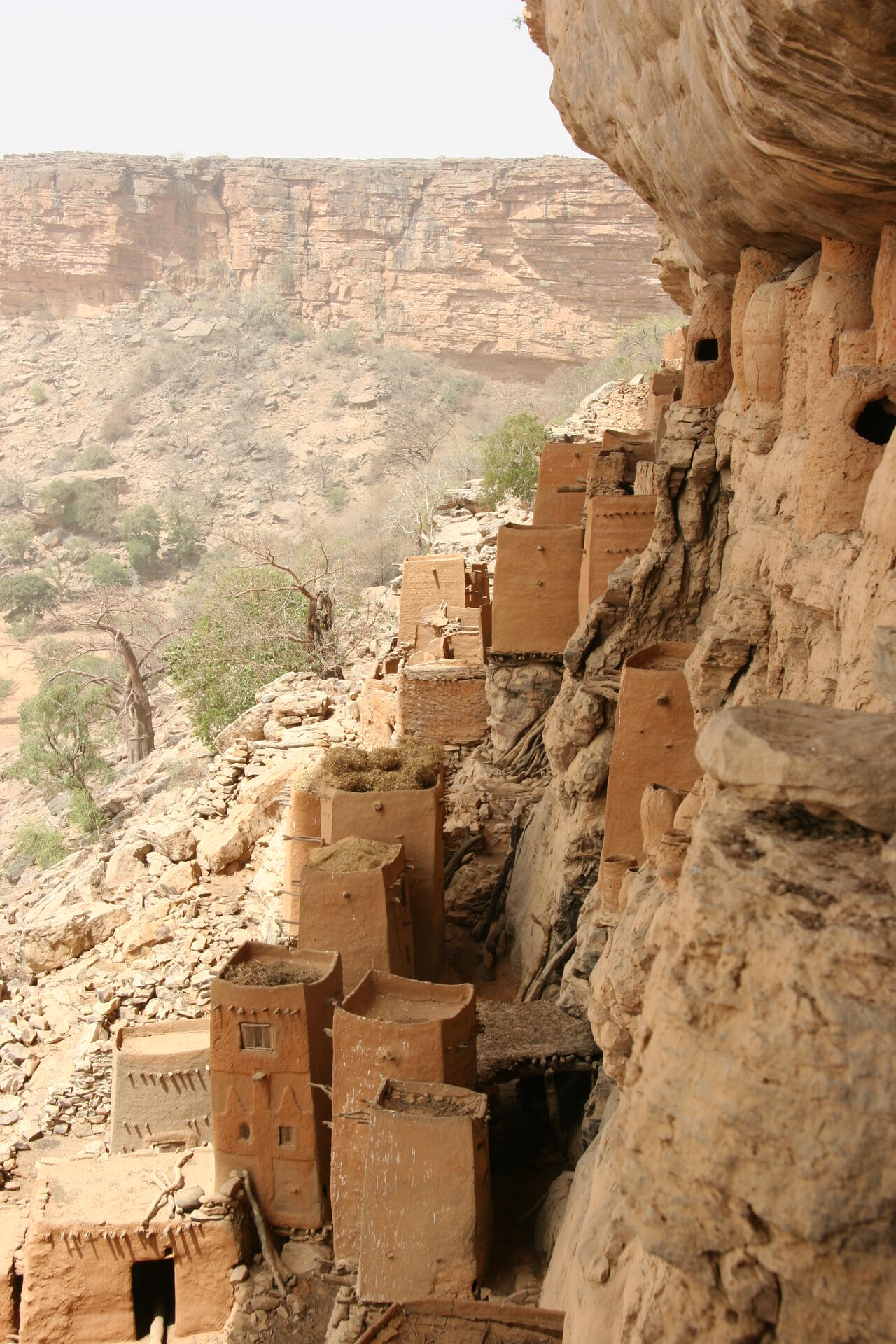
The Bandiagara Escarpment, colloquially known as the Cliff of Bandiagara or Land of the Dogons, stands as a testament to the harmonious blend of geology, history, and culture in the heart of West Africa. This remarkable sandstone cliff stretches over 150 kilometers (90 miles) in length and towers approximately 500 meters (1,600 feet) above the surrounding sandy plains in the Dogon Country of Mali. Recognized by UNESCO for its outstanding cultural significance within a dramatic natural setting, the site offers a unique glimpse into the heritage of the Dogon people while showcasing the imposing beauty of its geological formation.
Geologically, the escarpment is composed primarily of sandstone and other sedimentary formations that date back hundreds of millions of years, with many layers formed during the Precambrian and Paleozoic eras. Over time, erosion sculpted the rugged cliffs and plateaus that characterize this natural wonder. The escarpment serves as a dramatic backdrop for the intricate network of villages built along the cliff face and across the plateau and plains. Its varied elevations also create localized microclimatic conditions that support plant and animal life adapted to the environment within the Sahel region.
Long before the arrival of the Dogon people, the cliffs were inhabited by an earlier population known as the Tellem. Archaeological evidence suggests that the Tellem occupied the escarpment until around the 15th century. They are especially known for their burial caves constructed high in the cliff face. These elevated funerary chambers, still visible today, were likely intended to protect the deceased from seasonal flooding and wild animals.
When the Dogon later settled in the region—between the 13th and 15th centuries—they incorporated aspects of this preexisting sacred landscape into their own spiritual and architectural traditions, creating a layered cultural heritage embedded within the rock itself.
The Dogon people have preserved a rich cultural heritage that includes elaborate masked dances, rituals, and ceremonies associated with ancestor veneration and complex cosmological beliefs. Their society is traditionally organized around complex kinship systems and hierarchical religious structures, including the Hogon, a spiritual leader, which have been passed down through generations.
Architecturally, the Dogon settlements are renowned for their distinctive earthen structures, which reflect a deep spiritual connection to the land. Homes, cylindrical granaries with conical thatched roofs, altars, shrines, and communal meeting shelters known as Toguna (or Togu Na) are found throughout the region. Built primarily from mud brick, these structures are often decorated with symbolic motifs linked to Dogon cosmology and ancestral traditions. Their placement across different elevations of the escarpment demonstrates both environmental adaptation and social organization.
While aspects of Dogon culture have evolved over time, many traditions continue to play a vital role in community life. One of their most significant traditions is the Sigi festival, a rare ceremony held only once every 60 years—based on the cycle of the star Sirius—to mark the renewal of generations.
The significance of the Bandiagara Escarpment lies not only in its dramatic geology or its individual monuments, but in its character as a cultural landscape. Villages distributed across the plateau, along the cliff face, and on the plains below illustrate a centuries-long adaptation to the Sahelian environment. Agricultural terraces, granaries, water-management practices, and defensive settlement patterns reflect an intimate interaction between human communities and their terrain. The escarpment functions simultaneously as a natural fortification, a spiritual axis, and a structural foundation for daily life.
Overall, the Bandiagara Escarpment stands as a remarkable example of the interplay between geology, history, and culture. Its stunning landscapes, intricate architecture, and vibrant cultural traditions make it one of West Africa's most impressive sites, earning its designation as a UNESCO World Heritage Site. For travelers seeking a truly immersive experience in African history and culture, the Cliff of Bandiagara offers an unforgettable journey into the heart of the Dogon world.
UNESCO Description of the World Heritage Site
The Bandiagara site is an outstanding landscape of cliffs and sandy plateaux with some beautiful architecture (houses, granaries, altars, sanctuaries and Togu Na, or communal meeting-places). Several age-old social traditions live on in the region (masks, feasts, rituals, and ceremonies involving ancestor worship). The geological, archaeological and ethnological interest, together with the landscape, make the Bandiagara plateau one of West Africa's most impressive sites.
Encyclopedia Record: Bandiagara Escarpment
The Bandiagara Escarpment is a sandstone cliff in the Dogon country of Mali. It rises about 500 m (1,600 ft) above the lower sandy flats to the south, and has a length of approximately 150 km (90 mi).Additional Site Details
Area: 327,390 hectares
Number of Components: 2
(vii) — Contains superlative natural phenomena or beauty
Coordinates: 14.33333 , -3.41667
IUCN World Heritage Outlook
The 2025 Conservation Outlook on Cliff of Bandiagara (Land of the Dogons) reports the following assessment:
Source: International Union for Conservation of Nature (IUCN) · View assessment
Image
© Ferdinand Reus from Arnhem, the Netherlands, CC BY-SA 2.0 Resized from original. (This derivative is under the same CC BY-SA license.)
