World Heritage Identification Number: 414
World Heritage since: 1987
Category: Cultural Heritage
WHE Type: Archaeological Sites
Transboundary Heritage: No
Endangered Heritage: No
Country: 🇲🇽 Mexico
Continent: Americas
UNESCO World Region: Latin America and the Caribbean
Map
The Pre-Hispanic City of Teotihuacan: A Mesoamerican Cultural Hub
The Pre-Hispanic City of Teotihuacan, nestled within a sub-valley of the Valley of Mexico, offers a captivating glimpse into the rich cultural history of Mesoamerica. Located approximately 40 kilometers northeast of modern-day Mexico City, this ancient metropolis was built between the 1st and 7th centuries AD and was inscribed as a UNESCO World Heritage Site in 1987. At its height, Teotihuacan was one of the largest cities in the ancient world, with a population estimated at over 100,000 inhabitants.
Teotihuacan’s name, often translated as “the place where gods were born,” was given centuries later by the Aztecs and reflects the profound spiritual significance they attributed to the site. The city’s layout, characterized by the immense scale of its monuments and its carefully planned urban grid, serves as a testament to the ingenuity and ambition of its creators, whose precise identity remains unknown.
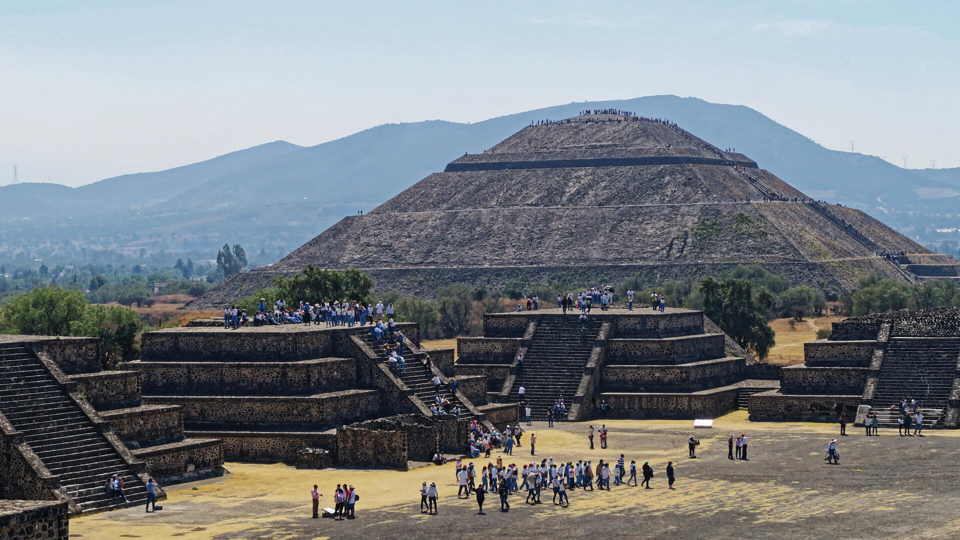
One of the most striking features of Teotihuacan is the Temple of the Feathered Serpent, dedicated to the feathered serpent deity. This temple, along with the Pyramid of the Sun and the Pyramid of the Moon, forms the ceremonial heart of the city. These structures were constructed according to sophisticated geometric and symbolic principles, with evidence suggesting astronomical alignments that reflect advanced observational knowledge.
The Pyramid of the Sun, the largest structure in the city, rises over 65 meters in height and was likely used for major religious ceremonies. At the northern end of the city’s main axis, the Pyramid of the Moon mirrors the surrounding landscape and anchors the monumental Avenue of the Dead, a grand central avenue lined with temples, plazas, and residential complexes.
In addition to its monumental architecture, the Pre-Hispanic City of Teotihuacan was a highly organized urban center characterized by sophisticated planning and a complex social structure. The city was laid out along a carefully aligned grid, oriented slightly east of north, with the Avenue of the Dead serving as its central axis. Surrounding this grand avenue were extensive apartment compounds that housed a diverse, multi-ethnic population, reflecting Teotihuacan’s role as a major hub of trade and cultural exchange.
This diversity is perhaps best exemplified by the Teopancazco apartment compound, a neighborhood located on the city's periphery. Recent bioarchaeological studies and oxygen isotope analysis of skeletal remains have revealed that Teopancazco was home to a transient and immigrant population hailing from the Gulf Coast, the Oaxacan highlands, and the central Mexican valleys. The presence of distinct ethnic groups living and working together underscores Teotihuacan’s identity not as a monolithic empire, but as a a diverse and dynamic urban center that drew people from across Mesoamerica.
Beyond its iconic structures, Teotihuacan exerted a far-reaching cultural and political influence across Mesoamerica. Evidence of its presence and interaction has been found in regions as distant as the Maya city of Tikal, demonstrating the widespread impact of Teotihuacan's civilization. From intricate murals depicting mythological scenes to delicate jade masks, the artistry of the Teotihuacanos continues to inspire awe and admiration.
Despite the passage of time and extensive research, much remains unknown about the people who built Teotihuacan. The city was not constructed by the Aztecs or the Maya, and its original inhabitants—often referred to as the Teotihuacanos—remain the subject of ongoing debate. Archaeologists continue to piece together its history through excavations and analysis, gradually uncovering insights into its social structure, economy, and eventual decline.
Teotihuacan's dominance was not permanent, despite its remarkable achievements. Beginning in the 6th century, the city experienced a period of decline, the causes of which remain debated among scholars. Evidence of widespread burning in elite and ceremonial structures suggests possible internal unrest or social upheaval, while environmental factors such as prolonged drought may have further strained resources.
The Pre-Hispanic City of Teotihuacan stands today as a testament to the ingenuity, complexity, and spiritual depth of ancient Mesoamerican civilizations. Its monumental architecture and enduring mysteries offer a powerful window into a past marked by innovation, cultural exchange, and profound symbolic expression. Teotihuacan endures not only as a symbol of ancient innovation and power but also as a reminder of the fragility of even the most advanced civilizations.
UNESCO Description of the World Heritage Site
The holy city of Teotihuacan ('the place where the gods were created') is situated some 50 km north-east of Mexico City. Built between the 1st and 7th centuries A.D., it is characterized by the vast size of its monuments – in particular, the Temple of Quetzalcoatl and the Pyramids of the Sun and the Moon, laid out on geometric and symbolic principles. As one of the most powerful cultural centres in Mesoamerica, Teotihuacan extended its cultural and artistic influence throughout the region, and even beyond.
Encyclopedia Record: Teotihuacan
Teotihuacan is an ancient Mesoamerican city located in a sub-valley of the Valley of Mexico, which is located in the State of Mexico, 40 kilometers (25 mi) northeast of modern-day Mexico City.Additional Site Details
Area: 250 hectares
(ii) — Significant interchange of human values
(iii) — Unique or exceptional testimony to a cultural tradition
(iv) — Outstanding example of a type of building or landscape
(vi) — Directly associated with events or living traditions
Coordinates: 19.69167 , -98.84167
Image
© Burkhard Mücke, CC BY-SA 4.0 Resized from original. (This derivative is under the same CC BY-SA license.)
