World Heritage Identification Number: 1405
World Heritage since: 2012
Category: Cultural Heritage
WHE Type: Archaeological Sites
Transboundary Heritage: No
Endangered Heritage: No
Country: 🇹🇷 Türkiye
Continent: Asia
UNESCO World Region: Europe and North America
Map
Unraveling the Mysteries of Çatalhöyük: A Journey Through Time
The Neolithic Site of Çatalhöyük, nestled on the Southern Anatolian Plateau in central Turkey, offers a remarkable glimpse into the early stages of settled human civilization. Covering approximately 37 hectares, this extensive archaeological site has been exceptionally well preserved, providing invaluable evidence for the transition from mobile hunter-gatherer societies to permanent farming communities.
The archaeological importance of Çatalhöyük was first recognized in 1958, and excavations began in 1961 under the direction of British archaeologist James Mellaart and his team. These early investigations revealed a remarkably preserved Neolithic settlement with richly decorated houses, numerous artifacts, and evidence of complex cultural practices. After a long interruption, excavations resumed in 1993 through the Çatalhöyük Research Project led by Ian Hodder, introducing new approaches that combined archaeology, conservation, and scientific analysis to explore the site's many dimensions.
The primary focus of Çatalhöyük is the taller eastern mound, where eighteen levels of Neolithic occupation have been unearthed, dating from approximately 7400 BC to 6200 BC. The site's significance lies in its distinctive streetless settlement, in which houses were built closely together with shared walls. Access to the dwellings was gained through openings in the roofs, creating an interconnected network of homes unlike those of most contemporary settlements. This unusual layout reflects a highly organized community and offers unique insights into early settlement planning and domestic life.
One of the most intriguing aspects of Çatalhöyük is the abundance of symbolic and artistic features preserved within its dwellings. Wall paintings, plaster reliefs, sculptures, decorated installations, and numerous artifacts reveal the rich cultural traditions and complex belief systems of its inhabitants. Many houses also contained burials beneath their floors, providing important evidence of family life, ritual practices, and ancestor veneration. Together, these discoveries offer exceptional insights into the social, religious, and cultural development of one of the world's earliest farming communities.
The inhabitants of Çatalhöyük developed a diverse economy based on agriculture, animal husbandry, hunting, and craft production. They cultivated crops such as wheat, barley, and legumes, raised sheep and goats, and continued to exploit wild resources from the surrounding landscape. Within their houses, people prepared food, produced tools, created textiles, and worked materials such as obsidian, which was obtained from nearby volcanic sources and widely used for making sharp tools and other objects. These activities reveal a sophisticated community with extensive knowledge of its environment and valuable regional connections.
The western mound at Çatalhöyük preserves evidence of occupation during the Chalcolithic (Copper Age), dating from approximately 6200 BC to 5200 BC. This era followed the Neolithic and preceded the Bronze Age, and it was characterized by the increasing use of copper alongside a continued reliance on stone tools. The western mound demonstrates the continuity of settlement at Çatalhöyük for more than two millennia and illustrates the gradual evolution of its cultural traditions.
The strategic location of Çatalhöyük on the Konya Plain further enhances its historical importance. Situated approximately 50 kilometers southeast of the modern city of Konya, the site occupies a fertile landscape that supported early agriculture and permanent settlement. It sits within clear sight of Mount Hasan, a twin-peaked volcano that dominates the horizon and forms a striking element of the region's natural landscape.
Çatalhöyük has transformed modern understanding of early settled societies by challenging traditional ideas about the origins of cities and social organization. Unlike later urban centers, the settlement contains no clear evidence of palaces, monumental temples, or elite residences, suggesting a community organized around households rather than centralized authority. Although scholars continue to debate the exact nature of social relationships at the site, Çatalhöyük provides exceptional evidence of how early farming communities developed complex forms of cooperation, ritual expression, and shared cultural identity.
In 2012, Çatalhöyük was inscribed on the UNESCO World Heritage List in recognition of its outstanding universal value and its exceptional testimony to the development of early settled communities. The site remains a major focus of archaeological research, continually enriching our understanding of early agriculture, social organization, architecture, and symbolic expression. As new discoveries continue to emerge, Çatalhöyük provides an unparalleled window into the lives of some of the world's earliest farming societies and the foundations of human civilization.
UNESCO Description of the World Heritage Site
Two hills form the 37 ha site on the Southern Anatolian Plateau. The taller eastern mound contains eighteen levels of Neolithic occupation between 7400 bc and 6200 bc, including wall paintings, reliefs, sculptures and other symbolic and artistic features. Together they testify to the evolution of social organization and cultural practices as humans adapted to a sedentary life. The western mound shows the evolution of cultural practices in the Chalcolithic period, from 6200 bc to 5200 bc. Çatalhöyük provides important evidence of the transition from settled villages to urban agglomeration, which was maintained in the same location for over 2,000 years. It features a unique streetless settlement of houses clustered back to back with roof access into the buildings.
UNESCO Justification of the World Heritage Site
Criterion (iii): Çatalhöyük provides a unique testimony to a moment of the Neolithic, in which the first agrarian settlements were established in central Anatolia and developed over centuries from villages to urban centres, largely based on egalitarian principles. The early principles of these settlements have been well preserved through the abandonment of the site for several millennia. These principles can be read in the urban plan, architectural structures, wall paintings and burial evidence. The stratigraphy of up to 18 settlement layers provides an exceptional testimony to the gradual development, re-shaping and expansion of the settlement.
Criterion (iv): The house clusters of Çatalhöyük, characterized by their streetless neighbourhoods, dwellings with roof access, and house types representing a highly circumscribed distribution of activity areas and features according to a clear spatial order aligned on cardinal directions, form an outstanding settlement type of the Neolithic period. The comparable sizes of the dwellings throughout the city illustrate an early type of urban layout based on community and egalitarian ideals.
Encyclopedia Record: Çatalhöyük
Çatalhöyük is a tell of a very large Neolithic and Chalcolithic proto-city settlement in southern Anatolia, which existed from approximately 7500 BC to 5600 BC and flourished around 7000 BC. In July 2012, it was inscribed as a UNESCO World Heritage Site. Çatalhöyük overlooks the Konya Plain, southeast of the present-day city of Konya in Turkey, approximately 140 km (87 mi) from the twin-coned volcano of Mount Hasan.Additional Site Details
Area: 37 hectares
Number of Components: 1
(iv) — Outstanding example of a type of building or landscape
Coordinates: 37.6666666667 , 32.8280555556
Image
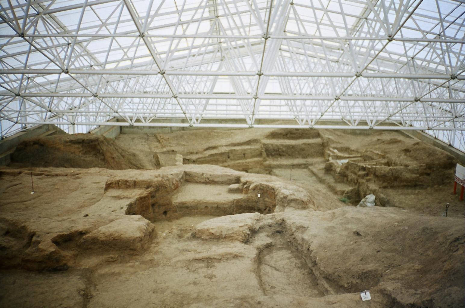
© Unknown, CC BY-SA 3.0 Resized from original. (This derivative is under the same CC BY-SA license.)