World Heritage Identification Number: 1725
World Heritage since: 2025
Category: Cultural Heritage
WHE Type: Archaeological Sites
Transboundary Heritage: No
Endangered Heritage: No
Country: 🇫🇷 France
Continent: Europe
UNESCO World Region: Europe and North America
Map
The Megaliths of Carnac and the Shores of Morbihan: A Neolithic Legacy
The Megaliths of Carnac and the Shores of Morbihan, inscribed as a UNESCO World Heritage Site in 2025, represent a remarkable testament to the Neolithic cultures that once thrived along the European Atlantic coast. This extensive collection of megalithic structures, primarily located in the Breton municipality of Carnac, offers unique insight into the societal organization, environmental understanding, and symbolic traditions of these Neolithic communities.
Although centered around Carnac, the UNESCO property extends across a far broader prehistoric landscape along the shores of Morbihan in Brittany. This includes a dense network of megalithic sites distributed across coastal zones, river valleys, peninsulas, and inland areas, forming a complex and interconnected ritual landscape rather than a single isolated monument field. Sites across the Gulf of Morbihan region are thought to have been linked through shared cultural practices, movement routes, and long-term patterns of territorial organization.
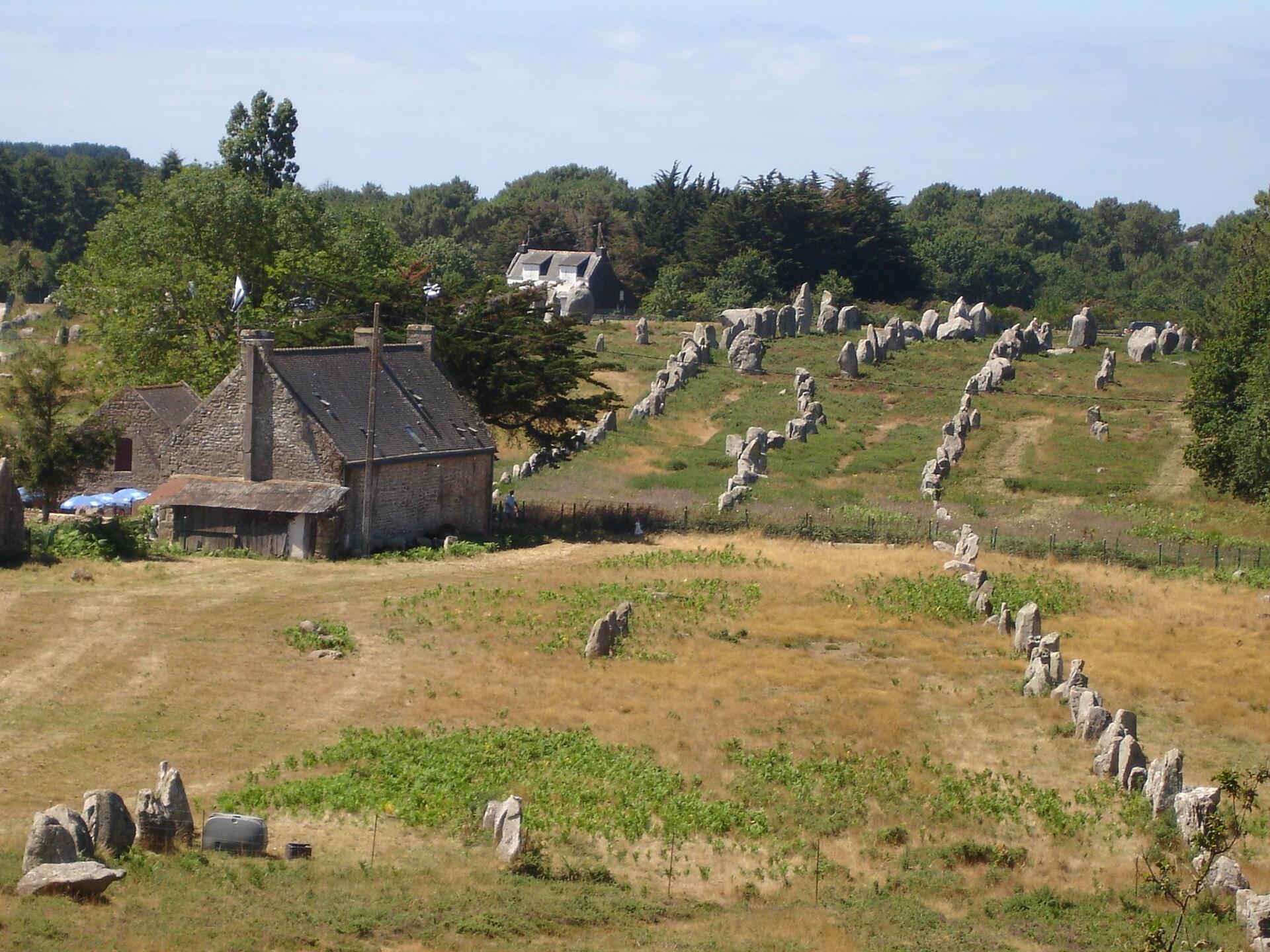
The Megaliths of Carnac consist of various types of megalithic monuments, including stone alignments, dolmens, tumuli, and individual menhirs. With over 3,000 prehistoric standing stones, this site forms one of the largest concentrations of prehistoric megalithic monuments in the world. The stones, hewn from local granite, were meticulously erected over a long period during the Neolithic era, approximately between 5000 and 2300 BCE, with many alignments dating to around 3300 BCE.
Stone alignments, or rows, are among the most prominent features of the Megaliths of Carnac. These linear arrangements of upright stones stretch for hundreds of meters, often following the contours of the landscape or aligning with natural landmarks such as hills, rivers, and coastal features. The purpose of these alignments remains a subject of debate among archaeologists, with theories ranging from astronomical alignment to ritualistic practices. The sheer scale and complexity of the alignments demonstrate a high degree of planning, cooperation, and technical skill among the Neolithic builders.
One of the most significant aspects of the Megaliths of Carnac and the Shores of Morbihan is their close relationship with the surrounding landscape. The monuments were carefully positioned in connection with hills, waterways, coastlines, and natural routes across the region, reflecting a sophisticated understanding of geography and environmental organization among Neolithic communities. UNESCO recognized the site not only for the scale of its megalithic constructions but also for the way these monuments form an interconnected cultural landscape shaped over thousands of years.
Dolmens, another common type of megalithic structure found in the region, are table-like constructions made up of three or more large vertical stones supporting a horizontal capstone. Many of these structures contain burial chambers, suggesting they functioned as ceremonial or funerary spaces within Neolithic society. The rich engravings adorning many of these dolmens offer valuable insights into the artistic traditions and symbolic language of the Neolithic inhabitants.
Tumuli, or burial mounds, are another significant component of the megalithic landscape. These earthen mounds, sometimes covered in stones, served as collective burial monuments for multiple individuals and communities. Their construction reflects complex funerary practices and suggests the existence of organized social structures and shared spiritual beliefs among the Neolithic populations of the region.
Individual menhirs, or free-standing standing stones, can also be found throughout the UNESCO property. Varying greatly in size and form, these solitary monoliths may have served as territorial markers, ceremonial symbols, memorials, or focal points within the wider ritual landscape. Some menhirs were later incorporated into Christian traditions and local folklore, demonstrating the enduring cultural significance of these monuments across centuries.
The Megaliths of Carnac and the Shores of Morbihan provide an extraordinary glimpse into the lives, beliefs, and achievements of Neolithic communities along the Atlantic coast of Europe. Through the study of these monuments and the archaeological evidence associated with them, historians and archaeologists continue to deepen our understanding of prehistoric society, spirituality, and environmental adaptation. As a UNESCO World Heritage Site, the megaliths stand not only as enduring reminders of humanity’s distant past but also as powerful symbols of the importance of preserving cultural heritage for future generations.
UNESCO Description of the World Heritage Site
This serial property in Brittany, France, features a dense concentration of megalithic structures built during the Neolithic period (c. 5000–2300 BCE), carefully aligned with the area’s unique geomorphology. These monumental stone constructions—arranged in relation to one another and to natural features like terrain and waterways—reflect a sophisticated understanding of the environment. Rich engravings and associated artifacts further illustrate the cultural complexity of the societies that inhabited this part of the European Atlantic coast.
UNESCO Justification of the World Heritage Site
Criterion (i): By reason of their scale, density and diversity, the Megaliths of Carnac and of the shores of Morbihan represent an exceptional testament to the technological sophistication and skilfulness of the Neolithic communities, which enabled them to extract, transport and handle monumental stones and earth to create a complex symbolic space that reveals a specific relationship of the people to their living environment. A rich repertoire of engravings of remarkable density includes representational art which is rarely documented in the megalithic contexts and constitutes one of the earliest examples of this type in Western Europe.
Criterion (iv): The Megaliths of Carnac and of the shores of Morbihan, spread over a vast area, are an outstanding example of an architectural ensemble that represents the transition to a new way of human interaction with the environment, involving the construction of monumental structures according to a specific orientation towards topographical features, visual interconnections and in relation to the geomorphology of the area. The megalithism of the Morbihan region testifies to over 2,000 years of human activity in this territory and marks a significant stage in the human history of ideological transformations that accompanied the process of neolithisation of Western Europe.
Encyclopedia Record: Carnac stones
The Carnac stones are an exceptionally dense collection of megalithic sites near the south coast of Brittany in northwestern France, consisting of stone alignments (rows), dolmens, tumuli and single menhirs. More than 3,000 prehistoric standing stones were hewn from local granite and erected by the pre-Celtic people of Brittany and form the largest such collection in the world. Most of the stones are within the Breton municipality of Carnac, but some to the east are within neighboring La Trinité-sur-Mer. The stones were erected at some stage during the Neolithic period, probably around 3300 BC, but some may date to as early as 4500 BC.Additional Site Details
Area: 19,598 hectares
Number of Components: 4
(iv) — Outstanding example of a type of building or landscape
Coordinates: 47.6161111111 , -3.0872222222
Image
© --Pinpin 17:43, 1 August 2006 (UTC), CC BY-SA 3.0 Resized from original. (This derivative is under the same CC BY-SA license.)
