
World Heritage Identification Number: 1279
World Heritage since: 2009
Category: Cultural Heritage
WHE Type: Natural Landscapes & Geographic Features
Transboundary Heritage: No
Endangered Heritage: No
Country: 🇨🇳 China
Continent: Asia
UNESCO World Region: Asia and the Pacific
Map
Sacred Buddhist Mountain: An Exploration of Mount Wutai
Mount Wutai, officially named Wutaishan and colloquially referred to as Mount Qingliang, is a significant cultural landscape located in the Shanxi Province of China. This sacred Buddhist mountain stands out as the highest in Northern China, boasting a unique morphology characterized by steep, treeless peaks arranged in a cardinal direction pattern. The central area of Mount Wutai is encompassed by a cluster of these flat-topped peaks or mesas.
More to come…UNESCO Description of the World Heritage Site
With its five flat peaks, Mount Wutai is a sacred Buddhist mountain. The cultural landscape is home to forty-one monasteries and includes the East Main Hall of Foguang Temple, the highest surviving timber building of the Tang dynasty, with life-size clay sculptures. It also features the Ming dynasty Shuxiang Temple with a huge complex of 500 statues representing Buddhist stories woven into three-dimensional pictures of mountains and water. Overall, the buildings on the site catalogue the way in which Buddhist architecture developed and influenced palace building in China for over a millennium. Mount Wutai, literally, 'the five terrace mountain', is the highest in Northern China and is remarkable for its morphology of precipitous slopes with five open treeless peaks. Temples have been built on this site from the 1st century AD to the early 20th century.
UNESCO Justification of the World Heritage Site
Criterion (ii): The overall religious temple landscape of Mount Wutai, with its Buddhist architecture, statues and pagodas reflects a profound interchange of ideas, in terms of the way the mountain became a sacred Buddhist place, endowed with temples that reflected ideas from Nepal and Mongolia and which then influenced Buddhist temples across China.
Criterion (iii): Mount Wutai is an exceptional testimony to the cultural tradition of religious mountains that are developed with monasteries. It became the focus of pilgrimages from across a wide area of Asia, a cultural tradition that is still living.
Criterion (iv): The landscape and building ensemble of Mount Wutai as a whole illustrates the exceptional effect of imperial patronage over a 1,000 years in the way the mountain landscape was adorned with buildings, statuary, paintings and steles to celebrate its sanctity for Buddhists.
Criterion (vi): Mount Wutai reflects perfectly the fusion between the natural landscape and Buddhist culture, religious belief in the natural landscape and Chinese philosophical thinking on the harmony between man and nature. The mountain has had far-reaching influence: mountains similar to Wutai were named after it in Korea and Japan, and also in other parts of China such as Gansu, Shanxi, Hebei and Guandong provinces.
Encyclopedia Record: Mount Wutai
Mount Wutai, also known by its Chinese name Wutaishan and as Mount Qingliang, is a sacred Buddhist site at the headwaters of the Qingshui in Shanxi Province, China. Its central area is surrounded by a cluster of flat-topped peaks or mesas roughly corresponding to the cardinal directions. The north peak is the highest and is also the highest point in North China.Additional Site Details
Area: 18,415 hectares
Number of Components: 2
(iii) — Unique or exceptional testimony to a cultural tradition
(iv) — Outstanding example of a type of building or landscape
(vi) — Directly associated with events or living traditions
Coordinates: 39.0305555556 , 113.5633333333
Image
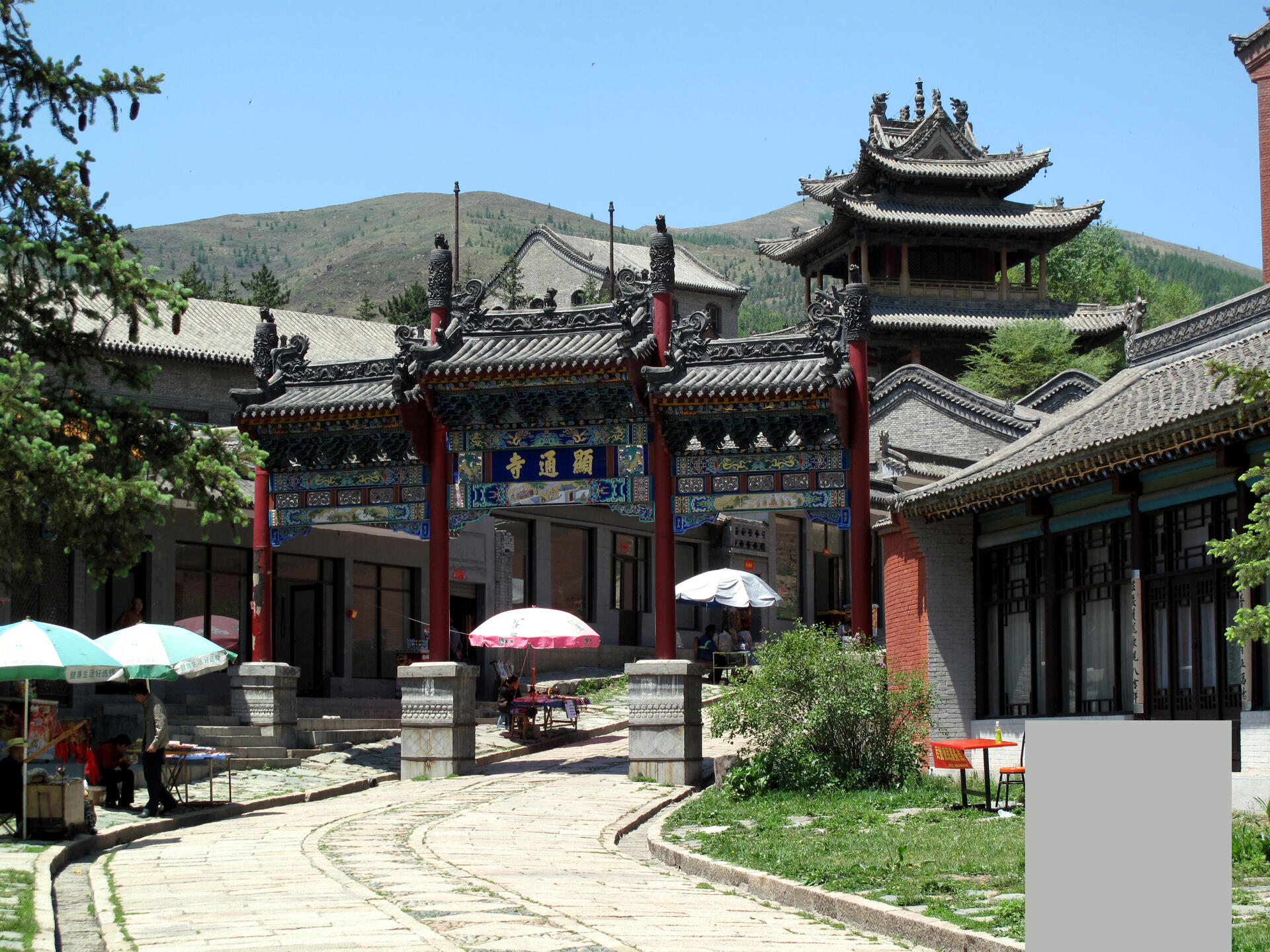
© G41rn8, CC BY-SA 4.0 Resized from original. (This derivative is under the same CC BY-SA license.)
World Heritage Research
Discover scientific research and academic studies that deepen our understanding of Mount Wutai from its history and significance to its conservation, management, and contemporary challenges.
-
Buddhist heritage landscape evolution of Mount Wutai: a path dependence approach
Path dependence analysis reveals how self-reinforcing sequences shape the evolution of Buddhist heritage landscapes, offering a toolkit to steer their development toward desired outcomes. The study applies this framework to Mount Wutai's landscape, demonstrating its utility for long-term cultural preservation and sustainable management. By examining institutional genesis, reproduction, and change over millennia, researchers identify key mechanisms that influence landscape trajectories, providing actionable insights for heritage conservation.
Wang, W., Lu, Z., Zhang, Z., Zhou, J., & Gong, Z. (2024). Buddhist heritage landscape evolution of Mount Wutai: a path dependence approach. Landscape Research, 49(4), 527–539. https://doi.org/10.1080/01426397.2024.2317728
View Publication Record | Read Publication -
Response of the Alpine Timberline to Residual Permafrost Degradation in Mount Wutai
Alpine timberlines on Mount Wutai exhibit a dynamic response to permafrost degradation, characterized by an initial upward shift followed by stabilization or slight decline. This pattern reflects the dual role of permafrost: initially supporting vegetation growth through water and nutrient provision during melting phases, but later undermining stability as its structural and hydrological functions diminish. Analyzing meteorological data and remote sensing from 2001 to 2021, researchers observed that timberlines rose consistently between 2000–2014 due to permafrost thaw, but this trend reversed or stalled post-2014 as residual permafrost near the timberline disappeared. The study highlights the complex interplay between vegetation and permafrost degradation, offering insights into the ecological consequences of climate change in alpine ecosystems.
Shan, W., Hou, P., Wang, Y., Qiu, L., Guo, Y., & Zhang, C. (2024). Response of the Alpine Timberline to Residual Permafrost Degradation in Mount Wutai. Forests, 15(4), 651. https://doi.org/10.3390/f15040651
View Publication Record | Read Publication -
Tracking the Drivers of the Tourism Ecological Footprint in Mount Wutai, China, Based on the STIRPAT Model
A significant increase in the tourism ecological footprint at Mount Wutai, China, from 27,798.07 gha in 2005 to 67,467.36 gha in 2019 was driven by rising tourist arrivals, ticket revenue, and national passenger turnover, despite a decline in energy intensity. An extended STIRPAT model revealed that while economic growth did not alleviate environmental pressure—contrary to the Environmental Kuznets Curve hypothesis—a 1% increase in energy intensity could reduce the ecological footprint by 0.108%. These findings underscore the need for policy interventions and technological innovation to mitigate tourism's environmental impact on this UNESCO World Heritage Site.
Shuzheng, L., Jianshu, Y., Hailong, B., & Fuyan, C. (2023). Tracking the Drivers of the Tourism Ecological Footprint in Mount Wutai, China, Based on the STIRPAT Model. Journal of Resources and Ecology, 14(5). https://doi.org/10.5814/j.issn.1674-764x.2023.05.016
View Publication Record | Read Publication -
Mount Wutai: Visions of a Sacred Buddhist Mountain
Mount Wutai emerges as a pivotal site of cultural, religious, and political interaction for Inner Asian Buddhists. Wen-shing Chou's work highlights its significance as a sacred Buddhist mountain, showcasing its role in shaping spiritual practices, artistic traditions, and political dynamics across centuries. The study employs a multidisciplinary approach, integrating historical analysis with art history to elucidate the mountain's influence on Buddhist culture and its enduring legacy.
Campbell, A. (2020). Mount Wutai: Visions of a Sacred Buddhist Mountain. Ming Studies, 2020(81), 91–94. https://doi.org/10.1080/0147037x.2020.1735825
View Publication Record | Read Publication -
Monitoring Land Cover Change and Disturbance of the Mount Wutai World Cultural Landscape Heritage Protected Area, Based on Remote Sensing Time-Series Images from 1987 to 2018
Mount Wutai exhibited remarkable stability in its land cover and disturbance levels from 1987 to 2018 despite significant changes in forest coverage, vegetation conditions, mining areas, and built-up zones. This resilience was quantified using the Comprehensive Heritage Area Threats Index (CHATI), which integrated multi-source remote sensing data to assess threats at both macro and micro levels. The study employed linear regression and F-tests to identify spatial-temporal variations, with field validation confirming the reliability of its findings. While challenges persist, this approach offers a robust tool for raising public awareness and improving governance of World Heritage Areas.
Bai, X., Du, P., Guo, S., Zhang, P., Lin, C., Tang, P., & Zhang, C. (2019). Monitoring Land Cover Change and Disturbance of the Mount Wutai World Cultural Landscape Heritage Protected Area, Based on Remote Sensing Time-Series Images from 1987 to 2018. Remote Sensing, 11(11), 1332. https://doi.org/10.3390/rs11111332
View Publication Record | Read Publication -
The Transnational Cult of Mount Wutai
Mount Wutai, a UNESCO World Heritage Site in China, has been a sacred place for over 1500 years, with its significance extending across East Asia. This study reveals how both local actors and distant individuals have collaboratively shaped and reshaped Mount Wutai's status as a holy site through the centuries. By analyzing familiar visual and textual sources alongside understudied noncanonical materials, the research provides new insights into the dynamic nature of sacred geography and its evolution over time.
Andrews, S., Chen, J., & Kuan, G. (2021). The Transnational Cult of Mount Wutai. https://doi.org/10.1163/9789004419872
View Publication Record | Read Publication -
Buddhist Revival in China: Values of the Development of Mount Wutai
Mount Wutai, a UNESCO World Heritage Site and historic Buddhist sacred mountain, has undergone significant development since the 1980s due to the interplay of Buddhist revivalism and politically motivated secularization. The study reveals that the Chinese government's recognition of Mount Wutai's secular values—such as tourism and economic potential—has reshaped its political environment, benefiting the local community, Buddhist community, and the Party-state. This shift contrasts with the suppression of religious groups during the Cultural Revolution and reflects a strategic approach by the CCP to leverage religion for broader societal goals.
Zhang, C. (2016). Buddhist Revival in China: Values of the Development of Mount Wutai [University of Alberta Library]. https://doi.org/10.7939/R3Z60CC41
View Publication Record | Read Publication -
Retention of Atmospheric Particles by Local Plant Leaves in the Mount Wutai Scenic Area, China
Broad-leaved plants, particularly Populus davidiana (Po. davidiana), Rosa hugonis Hemsl. (R. hugonis), and Betula platyphylla Suk. (B. platyphylla), are highly effective in retaining atmospheric particles in the Mount Wutai scenic area, significantly contributing to air purification. The study found that these plants can retain up to 38.60 ± 18.32 mg/cm² of suspended particles before rain, with a substantial reduction observed post-rainfall (0.65 ± 0.23 to 3.50 ± 1.83 mg/cm²). The research analyzed eight plant species, assessing their particle retention capabilities through metrics such as weight, light-shaded area, and horizontal density of particles on leaves. While broad-leaved plants demonstrated superior performance, needle-leaved species like Pinus tabuliformis Carrière (Pi. tabuliformis) were found to be less effective for air purification in this context.
Shi, S., Wu, Z., Liu, F., & Fan, W. (2016). Retention of Atmospheric Particles by Local Plant Leaves in the Mount Wutai Scenic Area, China. Atmosphere, 7(8), 104. https://doi.org/10.3390/atmos7080104
View Publication Record | Read Publication -
Characteristics of PM10 and PM2.5 at Mount Wutai Buddhism Scenic Spot, Shanxi, China
Airborne particulate pollution at Mount Wutai, a UNESCO World Heritage Site in Shanxi, China, exceeds WHO air quality guidelines by 1.01–1.14 times for PM10 and 1.75–2.70 times for PM2.5 during peak tourist season. Particle size analysis revealed distinct distributions across four sampling locations: Wu Ye Temple (core incense burners) showed fine particulates ranging from 0 to 3.30 μm, while other sites exhibited larger ranges up to 5.90 μm. Particulates in Wu Ye Temple were primarily spherical, rod-like, and irregular soot aggregates for PM10, with spherical dust particles for PM2.5. Manjusri Temple and Yang Bai Lin Village predominantly featured irregular soil mineral matter (PM10) and amorphous ultrafine soot (PM2.5). This study highlights the significant impact of human activities on air quality in this culturally significant landscape.
Wu, Z., Liu, F., & Fan, W. (2015). Characteristics of PM10 and PM2.5 at Mount Wutai Buddhism Scenic Spot, Shanxi, China. Atmosphere, 6(8), 1195–1210. https://doi.org/10.3390/atmos6081195
View Publication Record | Read Publication -
The Five-Colored Clouds of Mount Wutai: Poems from Dunhuang
A collection of Chinese Buddhist poems from the Dunhuang manuscripts, analyzed by Mary Anne Cartelli, reveals significant literary evidence for Mount Wutai's transformation into the earthly paradise of the bodhisattva Manjuśrī during the Tang dynasty. The poems, titled 'The Five-Colored Clouds of Mount Wutai,' depict the mountain as a sacred and revered site, offering insights into its cultural and religious significance in Buddhist tradition. This study provides a unique perspective on the evolution of Mount Wutai's symbolic importance, enriching our understanding of its role in Tang dynasty spirituality.
Cartelli, M. A. (2013). The Five-Colored Clouds of Mount Wutai: Poems from Dunhuang. https://doi.org/10.1163/9789004241763
View Publication Record | Read Publication
